IMAGES TAKEN NEAR TO
Maes Gwynedd, CAERNARFON, LL55 1DL
Introduction
This page details the photographs taken nearby to Maes Gwynedd, LL55 1DL by members of the Geograph project.
The Geograph project started in 2005 with the aim of publishing, organising and preserving representative images for every square kilometre of Great Britain, Ireland and the Isle of Man.

There are currently over 7.5m images from over14,400 individuals and you can help contribute to the project by visiting https://www.geograph.org.uk
Image Map
Images are licensed for reuse under creativecommons.org/licenses/by-sa/2.0
Notes
- Clicking on the map will re-center to the selected point.
- The higher the marker number, the further away the image location is from the centre of the postcode.
Image Listing (25 Images Found)
Images are licensed for reuse under creativecommons.org/licenses/by-sa/2.0
Image
Details
Distance
1
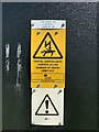
Signs at Cae Bold Substation, Caernarfon
See also Image
Image: © Meirion
Taken: 19 Apr 2024
0.12 miles
2
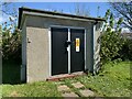
Cae Bold substation on Ffordd Cwellyn, Caernarfon
See also Image
Image: © Meirion
Taken: 19 Apr 2024
0.12 miles
3
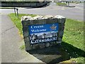
Croeso / Welcome monument on Ffordd Bethel, Caernarfon
Croeso
Welcome
Caernarfon
Image: © Meirion
Taken: 19 Apr 2024
0.13 miles
4
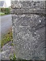
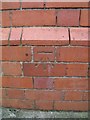
Benchmark on Ffordd Bethel, Caernarfon
This worn benchmark is located on a gatepost on the SE side of Ffordd Bethel in Caernarfon & it is shown in the current Ordnance Survey database at a height of 51.7427m above the Newlyn datum.
Image: © Meirion
Taken: 17 Feb 2011
0.13 miles
5
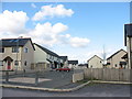
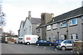
New Local Authority housing at Maesincla
Image: © Eric Jones
Taken: 20 Mar 2007
0.14 miles
6
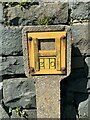
Hydrant marker on Ffordd Bethel, Caernarfon
Image: © Meirion
Taken: 19 Apr 2024
0.15 miles
7
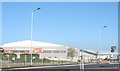
The Leisure Centre and Tennis Centre, Bethel Road
Image: © Eric Jones
Taken: 15 Oct 2006
0.16 miles
8
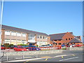
Ysgol Syr Hugh Owen School
A comprehensive secondary school serving the town of Caernarfon and the immediate area outside the town. It is named in honour of Sir Hugh Owen, a pioneer of Welsh secondary and tertiary education Image
Image: © Eric Jones
Taken: 15 Oct 2006
0.19 miles
9
Benchmark on Ysgol Syr Hugh Owen, Caernarfon
This benchmark is located on the SE face of Ysgol Syr Hugh Owen in Caernarfon & it is shown in the current Ordnance Survey database at a height of 51.6742m above the Newlyn datum.
Image: © Meirion
Taken: 17 Feb 2011
0.19 miles
10
Plas Maesincla Local Authority Residential Home
Image: © Eric Jones
Taken: 20 Mar 2007
0.21 miles