IMAGES TAKEN NEAR TO
Maes Cadnant, CAERNARFON, LL55 1BS
Introduction
This page details the photographs taken nearby to Maes Cadnant, LL55 1BS by members of the Geograph project.
The Geograph project started in 2005 with the aim of publishing, organising and preserving representative images for every square kilometre of Great Britain, Ireland and the Isle of Man.

There are currently over 7.5m images from over14,400 individuals and you can help contribute to the project by visiting https://www.geograph.org.uk
Image Map
Images are licensed for reuse under creativecommons.org/licenses/by-sa/2.0
Notes
- Clicking on the map will re-center to the selected point.
- The higher the marker number, the further away the image location is from the centre of the postcode.
Image Listing (126 Images Found)
Images are licensed for reuse under creativecommons.org/licenses/by-sa/2.0
Image
Details
Distance
2
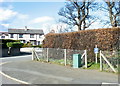
The junction of Ala Las and Ffordd Bethel (B4366)
The blue sign reading 'Dim Golff' indicates that Golf may not be played here.
Image: © Eric Jones
Taken: 20 Mar 2007
0.04 miles
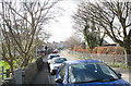
3
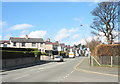
The town end of Ffordd Bethel
Below what once was called Gipsy Hill the Bethel Road reaches a roundabout where it joins the Llanberis-Tanrallt road. The mountains in the background are Yr Eifl.
Image: © Eric Jones
Taken: 20 Mar 2007
0.04 miles
4
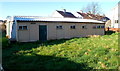
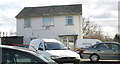
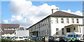
Hall on the corner of Maesincla Lane and Maes Cadnant, Caernarfon
At the late March 2012 date of this view, there was no name on the building to indicate its usage.
Image: © Jaggery
Taken: 26 Mar 2012
0.04 miles
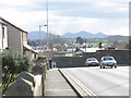
5
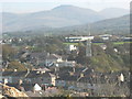
Houses in Hampton and Bethel Road from Twthill
The houses on Hampton and Lower Bethel Road are mostly Edwardian terraced houses with some additional infilling in the inter-war years. The large building behind Bethel Road is the Western Divisional HQ of the Heddlu Gogledd Cymru/North Wales Police.
Image: © Eric Jones
Taken: 24 Oct 2007
0.05 miles
6
SOC unit at Western Division HQ
The wording on the far van in the car park - Uned Archwilio Lleoliad Troseddau translates as Unit for Examination of Crime Scenes. The other has the words Uned Cefnogaeth Wyddonol Heddlu Gogledd Cymru North Wales Police Scientific Support Unit.
Image: © Eric Jones
Taken: 20 Mar 2007
0.06 miles
7
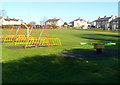
Children's play area, Maesincla Lane, Caernarfon
The play area is in the SE corner of a recreation ground.
Image: © Jaggery
Taken: 26 Mar 2012
0.06 miles
8
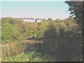
Cwm Cadnant Valley
The Afon Cadnant stream, although small, has carved a deep and narrow valley which bisects the town of Caernarfon. The lowest section of the river has been channelled underground.
Image: © Eric Jones
Taken: 24 Oct 2007
0.07 miles
10
Caernarfon Police Station and HQ Western Division
The police station is new building on the left. The older building is the Pencadlys Rhanbarth Orllewinol yr Heddlu /Western Divisional Police Headquarters.
Image: © Eric Jones
Taken: 20 Mar 2007
0.08 miles