IMAGES TAKEN NEAR TO
Carmel, CAERNARFON, LL54 7SW
Introduction
This page details the photographs taken nearby to LL54 7SW by members of the Geograph project.
The Geograph project started in 2005 with the aim of publishing, organising and preserving representative images for every square kilometre of Great Britain, Ireland and the Isle of Man.

There are currently over 7.5m images from over14,400 individuals and you can help contribute to the project by visiting https://www.geograph.org.uk
Image Map (Loading...)


Getting Data...Please wait
Leaflet Map data © OpenStreetMap
Images are licensed for reuse under creativecommons.org/licenses/by-sa/2.0
Notes
- Clicking on the map will re-center to the selected point.
- The higher the marker number, the further away the image location is from the centre of the postcode.
Image Listing (7 Images Found)
Images are licensed for reuse under creativecommons.org/licenses/by-sa/2.0
Image
Details
Distance
1
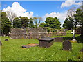
The Remains of St Thomas's Church, Groeslon
Built in the mid nineteenth century and now demolished.
Image: © Chris Andrews
Taken: 14 May 2017
0.19 miles
2
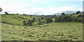
Mown hayfield in a small valley below Carmel
Image: © Eric Jones
Taken: 15 Jul 2008
0.19 miles
3
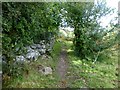
Footpath Starts Well
Our footpath started well on our route from the north towards the Caernarvon Fundamental Benchmark however we were soon in trouble when it became badly overgrown and a detour was required. It all looked so easy on the map.
Image: © Rude Health
Taken: 13 Sep 2015
0.20 miles
6
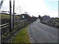
The Carmel to Groeslon road near Tyddyn Perthi
Image: © Eric Jones
Taken: 15 Jul 2008
0.24 miles
7
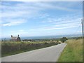
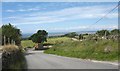
The steep descent on the Carmel-Groeslon road near Tyddyn Perthi
Image: © Eric Jones
Taken: 15 Jul 2008
0.25 miles