IMAGES TAKEN NEAR TO
Rhosgadfan, CAERNARFON, LL54 7HG
Introduction
This page details the photographs taken nearby to LL54 7HG by members of the Geograph project.
The Geograph project started in 2005 with the aim of publishing, organising and preserving representative images for every square kilometre of Great Britain, Ireland and the Isle of Man.

There are currently over 7.5m images from over14,400 individuals and you can help contribute to the project by visiting https://www.geograph.org.uk
Image Map
Images are licensed for reuse under creativecommons.org/licenses/by-sa/2.0
Notes
- Clicking on the map will re-center to the selected point.
- The higher the marker number, the further away the image location is from the centre of the postcode.
Image Listing (6 Images Found)
Images are licensed for reuse under creativecommons.org/licenses/by-sa/2.0
Image
Details
Distance
1
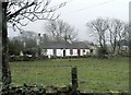
A Traditional White-washed Cottage, Ty'n Llwyn, Rhosgadfan.
Ty'n Llwyn, Rhosgadfan, an unspoilt traditional Tyddyn (croft) lies in the hills above Caernarfon.
Image: © Stephen Elwyn RODDICK
Taken: 13 Feb 2006
0.09 miles
2
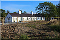
Old Welsh long house
Old farm cottage brought in to the 21st centrey
Image: © David C Williams
Taken: 17 Jun 2013
0.09 miles
4
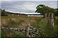
Gors - a former quarryman's small holding
This was farming on the margin.
Image: © Eric Jones
Taken: 15 Jul 2008
0.22 miles
5
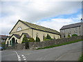
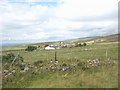
Capel Rhosgadfan Chapel
This Calvinistic Methodist chapel was built in 1876.
Image: © Eric Jones
Taken: 15 Jul 2008
0.24 miles
6
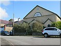
Capel Rhosgadfan 1876
Photographed by Eric Jones several years ago, but now looking abandoned and deteriorating with a few holes in the roof.
Image: © Gordon Hatton
Taken: 26 Sep 2023
0.25 miles