IMAGES TAKEN NEAR TO
Groeslon, CAERNARFON, LL54 7EN
Introduction
This page details the photographs taken nearby to LL54 7EN by members of the Geograph project.
The Geograph project started in 2005 with the aim of publishing, organising and preserving representative images for every square kilometre of Great Britain, Ireland and the Isle of Man.

There are currently over 7.5m images from over14,400 individuals and you can help contribute to the project by visiting https://www.geograph.org.uk
Image Map (Loading...)


Getting Data...Please wait
Leaflet Map data © OpenStreetMap
Images are licensed for reuse under creativecommons.org/licenses/by-sa/2.0
Notes
- Clicking on the map will re-center to the selected point.
- The higher the marker number, the further away the image location is from the centre of the postcode.
Image Listing (7 Images Found)
Images are licensed for reuse under creativecommons.org/licenses/by-sa/2.0
Image
Details
Distance
2
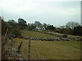
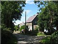
Braich-y-tri-gwr-bach - a derelict farmhouse undergoing reconstruction
Braich-y-tri-gwr means "ridge of the three men". There were two neighbouring farms with the same name, the result of medieval morselisation, so following the usual practice an adjective was added as a suffix to distinguish the two. Here the adjectives chosen were "bach" (=small) and "mawr" (=large).
Image: © Eric Jones
Taken: 15 Jul 2008
0.20 miles
5
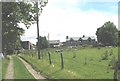
Local authority built estate at Maes Tryfan, Rhos Isa
Image: © Eric Jones
Taken: 15 Jul 2008
0.22 miles
6
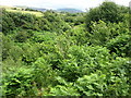
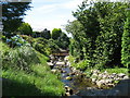
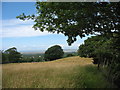
The sylvan incised valley of Afon Llifon
This is the river which nearer the sea flows past Plas Glynllifon Image, the seat of Glynnes who owned most of the land for miles around.
Image: © Eric Jones
Taken: 15 Jul 2008
0.22 miles