IMAGES TAKEN NEAR TO
Waunfawr, CAERNARFON, LL54 7BJ
Introduction
This page details the photographs taken nearby to LL54 7BJ by members of the Geograph project.
The Geograph project started in 2005 with the aim of publishing, organising and preserving representative images for every square kilometre of Great Britain, Ireland and the Isle of Man.

There are currently over 7.5m images from over14,400 individuals and you can help contribute to the project by visiting https://www.geograph.org.uk
Image Map (Loading...)


Getting Data...Please wait
Leaflet Map data © OpenStreetMap
Images are licensed for reuse under creativecommons.org/licenses/by-sa/2.0
Notes
- Clicking on the map will re-center to the selected point.
- The higher the marker number, the further away the image location is from the centre of the postcode.
Image Listing (9 Images Found)
Images are licensed for reuse under creativecommons.org/licenses/by-sa/2.0
Image
Details
Distance
3
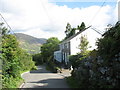
Braeside
The house is located on a steep hill running down to the A4085. It is typical of many of the detached houses in this area. The mountain in the background is Moel Eilio.
Image: © Eric Jones
Taken: 24 Aug 2006
0.19 miles
4
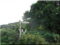
Signpost and Stile at the foot of Moel Smytho
The footpath follows a route across the hills to Fron 3.5 miles to the southwest. A former quarryman's path, it links the nearby village of Waunfawr with a number of small quarries.
Image: © Eric Jones
Taken: 24 Aug 2006
0.21 miles
5
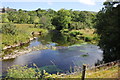
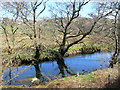
The Afon Gwyrfai
The Afon Gwyrfai taken from the Welsh Highland Railway near Waunfawr.
Image: © Jeff Buck
Taken: 17 Jul 2014
0.22 miles

7
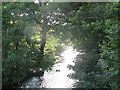
Afon Gwyrfai from Pont Cyrnant
This is view downstream from the narrow Cyrnant Bridge.
Image: © Eric Jones
Taken: 24 Aug 2006
0.23 miles
8
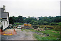
Waunfawr, Welsh Highland Railway station under restoration, 1999
View west from A4085, towards Dinas and Caernarfon, of early work in progress on the restoration of the former North Wales Narrow-Gauge Railway line, Dinas Junction - Beddgelert - Porthmadog, which was closed 7/37 (passengers 6/36). This restoration, funded and carried out by enthusiasts who eventually became the Ffestiniog & Welsh Highland Co. Ltd., was not completed through to Porthmadog until 2008 and to Porthmadog Harbour until 2011. (This is a very complicated story, which I may not have summarized correctly). [Moderator please check/confirm]. [?].
Image: © Ben Brooksbank
Taken: 14 Sep 1999
0.24 miles
9
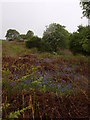
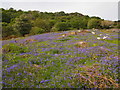
Bluebells, bracken and blossom
The lower slopes of Moel Smytho just above Parc Dudley are covered in proper bluebells, not the nasty Spanish type that seem to be taking over in many areas.
Image: © Paul Glover
Taken: 29 May 2010
0.24 miles