IMAGES TAKEN NEAR TO
Rhedyw Road, CAERNARFON, LL54 6SG
Introduction
This page details the photographs taken nearby to Rhedyw Road, LL54 6SG by members of the Geograph project.
The Geograph project started in 2005 with the aim of publishing, organising and preserving representative images for every square kilometre of Great Britain, Ireland and the Isle of Man.

There are currently over 7.5m images from over14,400 individuals and you can help contribute to the project by visiting https://www.geograph.org.uk
Image Map (Loading...)


Getting Data...Please wait
Leaflet Map data © OpenStreetMap
Images are licensed for reuse under creativecommons.org/licenses/by-sa/2.0
Notes
- Clicking on the map will re-center to the selected point.
- The higher the marker number, the further away the image location is from the centre of the postcode.
Image Listing (50 Images Found)
Images are licensed for reuse under creativecommons.org/licenses/by-sa/2.0
Image
Details
Distance
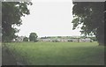
1
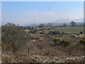
Side street with a view
This short side street off Rhedyw Road Llanllyfni has a view extending to the snow-capped Snowdon.
Image: © Eric Jones
Taken: 9 Mar 2010
0.03 miles
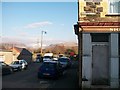
2
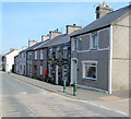
The back of Rhedyw Road from Lon Ty Gwyn
Llanllyfni is predominantly a linear settlement built along Rhedyw Road. Until the building of the bypass a decade ago this road was a particularly congested section of the A 487.
Image: © Eric Jones
Taken: 15 Jul 2008
0.05 miles
3
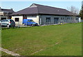
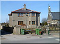
Memorial Hall, Llanllyfni
The name on the building is Neuadd Goffa Llanllyfni, Welsh for Llanllyfni Memorial Hall. The location is at the edge of a recreation ground on the east side of Ffordd Rhedyw, the main road through the village.
Image: © Jaggery
Taken: 24 Mar 2012
0.05 miles
4
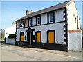
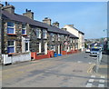
Boarded-up former Quarryman's Arms, Llanllyfni
Located alongside Ffordd Rhedyw, the main road through the village.
There were formerly several pubs in the village. This was the last one.
Image: © Jaggery
Taken: 24 Mar 2012
0.05 miles
5
Houses on the east side of Ffordd Rhedyw, Llanllyfni
Looking towards the boarded-up former Quarryman's Arms. http://www.geograph.org.uk/photo/3454019
Image: © Jaggery
Taken: 24 Mar 2012
0.05 miles
6
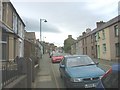
Ffordd Rhedyw Road
Until the building of a bypass a decade ago, this road was a particularly congested section of the A 487.
Image: © Eric Jones
Taken: 15 Jul 2008
0.06 miles
7
Stone houses with slate roofs, Ffordd Rhedyw, Llanllyfni
Ffordd Rhedyw is the main road through the village in Gwynedd.
Image: © Jaggery
Taken: 24 Mar 2012
0.06 miles
8
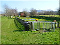
Children's play area, Llanllyfni
Located in a recreation area near the Memorial Hall. http://www.geograph.org.uk/photo/3454389
Image: © Jaggery
Taken: 24 Mar 2012
0.06 miles
9
View towards Llanllyfni from L?n Eifion Cycle Path
Afon Llyfni meandering in the foreground and still snow on the distant Snowdonia mountains
Image: © Eirian Evans
Taken: 9 Apr 2013
0.07 miles
10
Ty'n Llan, Llanllyfni
Ty'n Llan (Welsh for Glebe House) is in Ffordd Rhedyw, next to the village's parish church. http://www.geograph.org.uk/photo/3454449
The name plate shows the year 2000, so Ty'n Llan is probably a rebuild of an older house on this site.
Image: © Jaggery
Taken: 24 Mar 2012
0.08 miles