IMAGES TAKEN NEAR TO
Nebo, CAERNARFON, LL54 6RY
Introduction
This page details the photographs taken nearby to LL54 6RY by members of the Geograph project.
The Geograph project started in 2005 with the aim of publishing, organising and preserving representative images for every square kilometre of Great Britain, Ireland and the Isle of Man.

There are currently over 7.5m images from over14,400 individuals and you can help contribute to the project by visiting https://www.geograph.org.uk
Image Map (Loading...)


Getting Data...Please wait
Leaflet Map data © OpenStreetMap
Images are licensed for reuse under creativecommons.org/licenses/by-sa/2.0
Notes
- Clicking on the map will re-center to the selected point.
- The higher the marker number, the further away the image location is from the centre of the postcode.
Image Listing (7 Images Found)
Images are licensed for reuse under creativecommons.org/licenses/by-sa/2.0
Image
Details
Distance
1
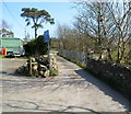
Lane unsuitable for HGVs, Pont y Lloc
The blue sign shows Unsuitable for heavy goods vehicles and its Welsh language equivalent.
Image: © Jaggery
Taken: 24 Mar 2012
0.08 miles
2
Glan-yr-afon houses, Pont y Lloc
Houses in a cul-de-sac in rural Gwynedd, north of Nebo.
Image: © Jaggery
Taken: 24 Mar 2012
0.10 miles
3
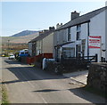
Houses near Pont y Lloc
The vehicles are parked at the edge of a row of 3 houses, numbers 1-3 Fron-dirion.
The location is rural Gwynedd, north of Nebo.
Image: © Jaggery
Taken: 24 Mar 2012
0.12 miles
4
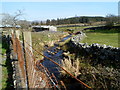
Afon Crychddwr near Pont y Lloc
Viewed from Ffordd Pont Lloc.
Image: © Jaggery
Taken: 24 Mar 2012
0.14 miles
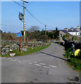
5
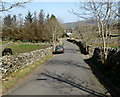
A bend in Ffordd Pont Lloc near Pont y Lloc
The location is rural Gwynedd north of Nebo.
Image: © Jaggery
Taken: 24 Mar 2012
0.15 miles
6
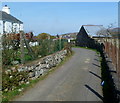
Ffordd Pont Lloc north of Nebo
Ffordd Pont Lloc heads away from Nebo towards Pont y Lloc.
Image: © Jaggery
Taken: 24 Mar 2012
0.21 miles
7
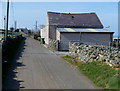
Cae-ffridd north of Nebo
A view west past Cae-ffridd in rural Gwynedd.
Image: © Jaggery
Taken: 24 Mar 2012
0.22 miles