IMAGES TAKEN NEAR TO
Llanllyfni, CAERNARFON, LL54 6RR
Introduction
This page details the photographs taken nearby to LL54 6RR by members of the Geograph project.
The Geograph project started in 2005 with the aim of publishing, organising and preserving representative images for every square kilometre of Great Britain, Ireland and the Isle of Man.

There are currently over 7.5m images from over14,400 individuals and you can help contribute to the project by visiting https://www.geograph.org.uk
Image Map (Loading...)


Getting Data...Please wait
Leaflet Map data © OpenStreetMap
Images are licensed for reuse under creativecommons.org/licenses/by-sa/2.0
Notes
- Clicking on the map will re-center to the selected point.
- The higher the marker number, the further away the image location is from the centre of the postcode.
Image Listing (16 Images Found)
Images are licensed for reuse under creativecommons.org/licenses/by-sa/2.0
Image
Details
Distance
1

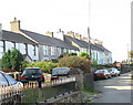
The Tanrallt Mountain Centre
The Tanrallt Mountain Centre is housed in a former chapel at the hamlet of Tanrallt. http://www.thetmc.co.uk
Image: © Eric Jones
Taken: 30 Sep 2006
0.03 miles

4
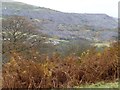
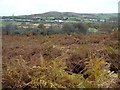
Autumn bracken, on the hillside west of Tanyrallt
As the valley side steepens, it changes from pasture to bracken and trees. The distant slate tips are west of Nantlle.
Image: © Christine Johnstone
Taken: 16 Nov 2013
0.14 miles
5

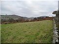
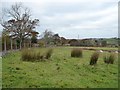
Field near Tanyrallt
The field is seen from a minor road descending to meet the B4418 east of Talysarn. Mynydd y Cilgwyn is shallow-sloped conical hill in the distance, its lower slopes scarred with extensive quarry spoil.
Image: © Trevor Littlewood
Taken: 5 Sep 2013
0.15 miles
6
Farmland west of Tanyrallt
On the north side of the minor road.
Image: © Christine Johnstone
Taken: 16 Nov 2013
0.15 miles
7
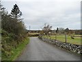
The road west from Tanyrallt
Looking towards a 117 metre spot height at the bend.
Image: © Christine Johnstone
Taken: 16 Nov 2013
0.17 miles
8
Bracken and trees, north of Taldrwst
Looking across the valley of Afon Llyfni towards the west end of Talysarn.
Image: © Christine Johnstone
Taken: 16 Nov 2013
0.17 miles
9
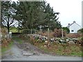
The entrance to Taldrwst
On the south side of the road from Tanyrallt, at the 117 metre spot height.
Image: © Christine Johnstone
Taken: 16 Nov 2013
0.17 miles
10
The 'rough' in rough grazing, near Taldrwst
Don't know the proper name for these pith-filled spikes, but they are very common on sheep pasture in Gwynedd.
Image: © Christine Johnstone
Taken: 16 Nov 2013
0.17 miles