IMAGES TAKEN NEAR TO
Ty'N Y Weirglodd, CAERNARFON, LL54 6RN
Introduction
This page details the photographs taken nearby to Ty'N Y Weirglodd, LL54 6RN by members of the Geograph project.
The Geograph project started in 2005 with the aim of publishing, organising and preserving representative images for every square kilometre of Great Britain, Ireland and the Isle of Man.

There are currently over 7.5m images from over14,400 individuals and you can help contribute to the project by visiting https://www.geograph.org.uk
Image Map (Loading...)


Getting Data...Please wait
Leaflet Map data © OpenStreetMap
Images are licensed for reuse under creativecommons.org/licenses/by-sa/2.0
Notes
- Clicking on the map will re-center to the selected point.
- The higher the marker number, the further away the image location is from the centre of the postcode.
Image Listing (54 Images Found)
Images are licensed for reuse under creativecommons.org/licenses/by-sa/2.0
Image
Details
Distance
1

Shell of a building, Penygroes
Located alongside Ty'n y Weirglodd, south of County Road.
Image: © Jaggery
Taken: 24 Mar 2012
0.04 miles
2

Maes Dulyn, Penygroes
Maes Dulyn is a short cul-de-sac on the west side of Ty'n y Weirglodd.
Image: © Jaggery
Taken: 24 Mar 2012
0.10 miles
3
Penygroes A'r Cylch Ex-Servicemens Club, Ffordd y Sir
There is a good mouthful of Wenglish It means Penygroes and District Ex-Servicemen's Club.
Image: © Eric Jones
Taken: 15 Jul 2008
0.11 miles
4

Penygroes Ex-Servicemens Club, Penygroes
Located in a 30 metre long single-storey building on the corner of County Road and Ty'n y Weirglodd.
Image: © Jaggery
Taken: 24 Mar 2012
0.11 miles
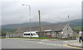
5
View across the roundabout to the Nantlle Vale Football Ground
www.nantlle.com/nantlle-vale-fc-saesneg.htm
Image: © Eric Jones
Taken: 15 Jul 2008
0.12 miles
6
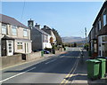
County Road, Penygroes
Looking ESE along the B4418 County Road towards the King's Road junction.
Image: © Jaggery
Taken: 24 Mar 2012
0.13 miles
7
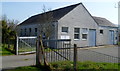
Penygroes telephone exchange
Located on the south side of the B4418.
Image: © Jaggery
Taken: 24 Mar 2012
0.13 miles
8
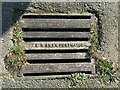
E.R.OWEN PORTHMADOG drain cover, Pen-y-groes
Image: © Meirion
Taken: 18 Mar 2022
0.14 miles
9
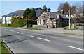
Turnpike and leisure centre, Penygroes
On the right is the distinctive Grade II listed cottage named Turnpike. http://www.geograph.org.uk/photo/3460790
On the left is Plas Silyn Leisure Centre. http://www.geograph.org.uk/photo/3460737
Viewed across the B4418 in the east of the village.
Image: © Jaggery
Taken: 24 Mar 2012
0.16 miles
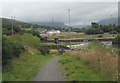
10
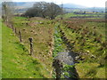
Drainage channel, Penygroes
Viewed from the B4418 looking SE. The channel drains into the Afon Llyfni, about 220 metres from the camera.
Image: © Jaggery
Taken: 24 Mar 2012
0.16 miles