IMAGES TAKEN NEAR TO
Penygroes, CAERNARFON, LL54 6PD
Introduction
This page details the photographs taken nearby to LL54 6PD by members of the Geograph project.
The Geograph project started in 2005 with the aim of publishing, organising and preserving representative images for every square kilometre of Great Britain, Ireland and the Isle of Man.

There are currently over 7.5m images from over14,400 individuals and you can help contribute to the project by visiting https://www.geograph.org.uk
Image Map (Loading...)


Getting Data...Please wait
Leaflet Map data © OpenStreetMap
Images are licensed for reuse under creativecommons.org/licenses/by-sa/2.0
Notes
- Clicking on the map will re-center to the selected point.
- The higher the marker number, the further away the image location is from the centre of the postcode.
Image Listing (3 Images Found)
Images are licensed for reuse under creativecommons.org/licenses/by-sa/2.0
Image
Details
Distance
2
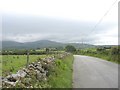
The link road between the A499 and the A487
This road improves in the direction of Penygroes but over much of its length is narrow and bendy.
Image: © Eric Jones
Taken: 15 Jul 2008
0.20 miles
3
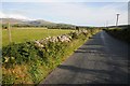
Country road near Penygroes
Country road to the west of Penygroes.
Image: © Philip Halling
Taken: 15 Aug 2014
0.24 miles