IMAGES TAKEN NEAR TO
Trem Engan, LL54 6HQ
Introduction
This page details the photographs taken nearby to Trem Engan, LL54 6HQ by members of the Geograph project.
The Geograph project started in 2005 with the aim of publishing, organising and preserving representative images for every square kilometre of Great Britain, Ireland and the Isle of Man.

There are currently over 7.5m images from over14,400 individuals and you can help contribute to the project by visiting https://www.geograph.org.uk
Image Map (Loading...)


Getting Data...Please wait
Leaflet Map data © OpenStreetMap
Images are licensed for reuse under creativecommons.org/licenses/by-sa/2.0
Notes
- Clicking on the map will re-center to the selected point.
- The higher the marker number, the further away the image location is from the centre of the postcode.
Image Listing (36 Images Found)
Images are licensed for reuse under creativecommons.org/licenses/by-sa/2.0
Image
Details
Distance
1
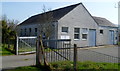
Penygroes telephone exchange
Located on the south side of the B4418.
Image: © Jaggery
Taken: 24 Mar 2012
0.04 miles
2
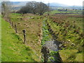
Drainage channel, Penygroes
Viewed from the B4418 looking SE. The channel drains into the Afon Llyfni, about 220 metres from the camera.
Image: © Jaggery
Taken: 24 Mar 2012
0.04 miles
3
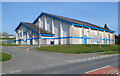
Plas Silyn Leisure Centre Penygroes
Located on the north side of the B4418 in the east of Penygroes.
Image: © Jaggery
Taken: 24 Mar 2012
0.04 miles
4
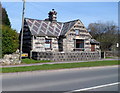
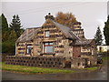
Grade II listed Turnpike, Penygroes
The distinctive cottage is on the north side of the B4418 near Plas Silyn Leisure Centre. http://www.geograph.org.uk/photo/3460737
The cottage was Grade II listed in July 2000.
Image: © Jaggery
Taken: 24 Mar 2012
0.04 miles
5
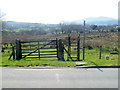
Wooden steps instead of a stile alongside the B4418, Penygroes
The steps on the right side of the gate have 5 rungs on each side, giving walkers access
to and from the field on the SW side of the B4418 in the east of Penygroes.
Image: © Jaggery
Taken: 24 Mar 2012
0.04 miles
7
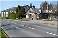
Turnpike and leisure centre, Penygroes
On the right is the distinctive Grade II listed cottage named Turnpike. http://www.geograph.org.uk/photo/3460790
On the left is Plas Silyn Leisure Centre. http://www.geograph.org.uk/photo/3460737
Viewed across the B4418 in the east of the village.
Image: © Jaggery
Taken: 24 Mar 2012
0.05 miles
8
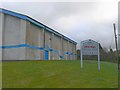
Plas Silyn, Penygroes
Fitness and Leisure Centre
Image: © Eirian Evans
Taken: 14 Nov 2008
0.05 miles
9
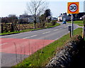
Start of the 30mph zone at the eastern edge of Penygroes
The National Speed Limit along the B4418 from Talysarn reduces to 30mph in Penygroes.
On the left, wooden steps http://www.geograph.org.uk/photo/3461705 give access to and from a field.
Image: © Jaggery
Taken: 24 Mar 2012
0.05 miles
10
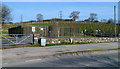
Gas governor, Penygroes
Located in a fenced compound on the north side of the B4418.
The function of a gas governor is to maintain optimal gas pressure in the National Grid.
Image: © Jaggery
Taken: 24 Mar 2012
0.05 miles