IMAGES TAKEN NEAR TO
Nasareth, CAERNARFON, LL54 6DR
Introduction
This page details the photographs taken nearby to LL54 6DR by members of the Geograph project.
The Geograph project started in 2005 with the aim of publishing, organising and preserving representative images for every square kilometre of Great Britain, Ireland and the Isle of Man.

There are currently over 7.5m images from over14,400 individuals and you can help contribute to the project by visiting https://www.geograph.org.uk
Image Map
Images are licensed for reuse under creativecommons.org/licenses/by-sa/2.0
Notes
- Clicking on the map will re-center to the selected point.
- The higher the marker number, the further away the image location is from the centre of the postcode.
Image Listing (4 Images Found)
Images are licensed for reuse under creativecommons.org/licenses/by-sa/2.0
Image
Details
Distance
1
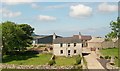
Ffermdy Bodychain Farmhouse
This fronts on to the A487
Image: © Eric Jones
Taken: 14 Jun 2010
0.01 miles
2
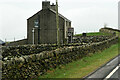
House next to the A487 near Bryn-ychain
Image: © David Dixon
Taken: 16 Feb 2022
0.11 miles
3
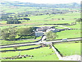
Bodychain
Bodychain has nothing to do with Blessed Matt Talbot or the Marquis de Sade; it is merely a Welsh word meaning 'the abode of oxen'. 'Bod' comes from the Old Irish 'both', which also gives the Scottish 'bothy' and 'ychain' are oxen. Bodychain is a pastoral farm located close to A487(T), also shown in the photograph.
Image: © Eric Jones
Taken: 9 Oct 2006
0.16 miles
4
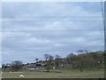
Brynychain, Nasareth
This stands below the Nebo transmission mast.
Image: © Eric Jones
Taken: 27 Mar 2010
0.22 miles