IMAGES TAKEN NEAR TO
Llanllyfni, CAERNARFON, LL54 6DH
Introduction
This page details the photographs taken nearby to LL54 6DH by members of the Geograph project.
The Geograph project started in 2005 with the aim of publishing, organising and preserving representative images for every square kilometre of Great Britain, Ireland and the Isle of Man.

There are currently over 7.5m images from over14,400 individuals and you can help contribute to the project by visiting https://www.geograph.org.uk
Image Map (Loading...)


Getting Data...Please wait
Leaflet Map data © OpenStreetMap
Images are licensed for reuse under creativecommons.org/licenses/by-sa/2.0
Notes
- Clicking on the map will re-center to the selected point.
- The higher the marker number, the further away the image location is from the centre of the postcode.
Image Listing (16 Images Found)
Images are licensed for reuse under creativecommons.org/licenses/by-sa/2.0
Image
Details
Distance
1
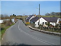
Bont y Crychddwr houses
The houses are on the south side of the bridge carrying the road over the Afon Crychddwr.
Image: © Jaggery
Taken: 24 Mar 2012
0.02 miles
2
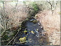
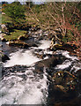
Afon Crychddwr at Bont y Crychddwr
Afon is Welsh for river, but Nant (stream) would be a better name for this small body of water viewed from Bont y Crychddwr on the road north to Llanllyfni.
Image: © Jaggery
Taken: 24 Mar 2012
0.02 miles
3
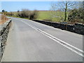
Stone walls of the bridge over Afon Crychddwr south of Llanllyfni
Maps show this location as Bont y Crychddwr but the name sign on the right shows Pont y Crychddwr.
Image: © Jaggery
Taken: 24 Mar 2012
0.04 miles
5
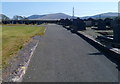
Road through a Llanllyfni cemetery
Located at the southern edge of the village, this is one of several cemeteries in Llanllyfni.
Image: © Jaggery
Taken: 24 Mar 2012
0.10 miles
6
Southern boundary of Llanllyfni
Llanllyfni is a village in Gwynedd, 11km (7 miles) south of Caernarfon.
The perimeter wall of the village cemetery is on the right.
Image: © Jaggery
Taken: 24 Mar 2012
0.10 miles
7
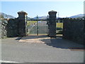
Cemetery gates, Llanllyfni
Located at the southern edge of the village, this is one of several cemeteries in Llanllyfni.
It occupies a rectangular site measuring about 80 yards (73m) by 60 yards (54m).
Image: © Jaggery
Taken: 24 Mar 2012
0.11 miles
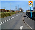
8
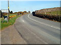
Slow - bends ahead for ? mile south of Llanllyfni
A view north along an unclassifieid road towards Llanllyfni.
Image: © Jaggery
Taken: 24 Mar 2012
0.15 miles
9
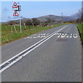
Humps for 550 yards in Llanllyfni
A sign informs drivers of the traffic calming measures ahead on the main road through the village.
Image: © Jaggery
Taken: 24 Mar 2012
0.18 miles
10
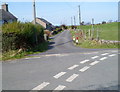
Lane to the A487 south of Llanllyfni
The lane passes Fron-deg and Efail y Berth.
Image: © Jaggery
Taken: 24 Mar 2012
0.18 miles