IMAGES TAKEN NEAR TO
Llanllyfni, CAERNARFON, LL54 6DD
Introduction
This page details the photographs taken nearby to LL54 6DD by members of the Geograph project.
The Geograph project started in 2005 with the aim of publishing, organising and preserving representative images for every square kilometre of Great Britain, Ireland and the Isle of Man.

There are currently over 7.5m images from over14,400 individuals and you can help contribute to the project by visiting https://www.geograph.org.uk
Image Map (Loading...)


Getting Data...Please wait
Leaflet Map data © OpenStreetMap
Images are licensed for reuse under creativecommons.org/licenses/by-sa/2.0
Notes
- Clicking on the map will re-center to the selected point.
- The higher the marker number, the further away the image location is from the centre of the postcode.
Image Listing (34 Images Found)
Images are licensed for reuse under creativecommons.org/licenses/by-sa/2.0
Image
Details
Distance
1
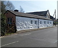
Long single-storey whitewashed house, Felin Gerrig, Llanllyfni
The 20 metre (66 ft) long building is next to Ebenezer Chapel. http://www.geograph.org.uk/photo/3454639
Image: © Jaggery
Taken: 24 Mar 2012
0.01 miles
2
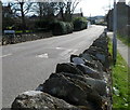
Postbox in a long wall, Llanllyfni
The postbox http://www.geograph.org.uk/photo/3454624 is on the left, near a broken part of the wall.
Image: © Jaggery
Taken: 24 Mar 2012
0.01 miles
3
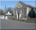
Ebenezer Chapel, Llanllyfni
Located alongside Felin Gerrig in the north of the village. The year 1826 on the building is the date of construction of the original chapel, which was modified and enlarged later in the 19th century.
Image: © Jaggery
Taken: 24 Mar 2012
0.01 miles
4
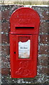
Edward VII postbox in a wall, Llanllyfni
The postbox bearing the King Edward VII monogram is in the wall here. http://www.geograph.org.uk/photo/3454619
Image: © Jaggery
Taken: 24 Mar 2012
0.02 miles
5
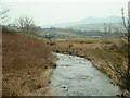
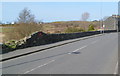
Afon Llyfni
Looking south west. The bridge in the distance is on the 'new' A487 trunk road.
Image: © David Medcalf
Taken: 23 Mar 2006
0.03 miles
6
Northern boundary of Llanllyfni
The road south from Penygroes passes the boundary sign for Llanllyfni,
a village in Gwynedd 11km (7 miles) south of Caernarfon.
Image: © Jaggery
Taken: 24 Mar 2012
0.04 miles
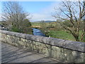
7
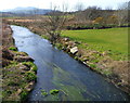
Afon Llyfni between Llanllyfni and Penygroes
Viewed from the footbridge alongside Pont Factory, the bridge carrying the road over the river.
Image: © Jaggery
Taken: 24 Mar 2012
0.06 miles
8
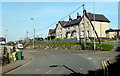
Houses near a bend in Ffordd Rhedyw, Llanllyfni
The houses are set back from the east side of Ffordd Rhedyw, the main road through the village.
Image: © Jaggery
Taken: 24 Mar 2012
0.09 miles
9
Afon Llyfni and Pont Factory parapet
Looking south west along Afon Llyfni from Pont Factory on Rhedyw Road. The bridge is named after a nearby Woollen Factory that is indicated to the north east on the 1889 O.S. map, but the remaining buildings now seem to be private houses. A modern footbridge is out of sight below the parapet making it safer for pedestrians to cross the river. There is an Ordnance Survey bench mark cut into this parapet close to the centre of the bridge - Image
Image: © John S Turner
Taken: 5 May 2018
0.09 miles
10

Bench mark on Pont Factory, north of Llanllyfni
This Ordnance Survey bench mark is on the west parapet of Pont Factory, which carries Rhedyw Road over the Afon Llyfni. The bridge is named after a nearby Woollen Factory that is indicated on the 1889 O.S. map, but the remaining buildings now seem to be private houses. See also Image
Image: © John S Turner
Taken: 5 May 2018
0.10 miles