IMAGES TAKEN NEAR TO
Nantlle, CAERNARFON, LL54 6BW
Introduction
This page details the photographs taken nearby to LL54 6BW by members of the Geograph project.
The Geograph project started in 2005 with the aim of publishing, organising and preserving representative images for every square kilometre of Great Britain, Ireland and the Isle of Man.

There are currently over 7.5m images from over14,400 individuals and you can help contribute to the project by visiting https://www.geograph.org.uk
Image Map (Loading...)


Getting Data...Please wait
Leaflet Map data © OpenStreetMap
Images are licensed for reuse under creativecommons.org/licenses/by-sa/2.0
Notes
- Clicking on the map will re-center to the selected point.
- The higher the marker number, the further away the image location is from the centre of the postcode.
Image Listing (23 Images Found)
Images are licensed for reuse under creativecommons.org/licenses/by-sa/2.0
Image
Details
Distance
1
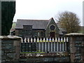
Baladeulyn Presbyterian Church
Built in 1865.
Image: © Eirian Evans
Taken: 14 Nov 2008
0.04 miles
4
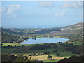
Llyn Nantlle Uchaf
Seen from Clogwyn y Barcut. Translated as "Higher Nantlle Lake", but there is no "Lower [Isaf] Nantlle Lake" - it was long since filled with slate waste. An area in Nantlle is still called "Bala" - the land between two lakes.
Image: © David Medcalf
Taken: 20 Sep 2009
0.12 miles
5
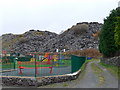
Playground at the foot of the spoil heaps, Nantlle
Image: © Eirian Evans
Taken: 14 Nov 2008
0.13 miles
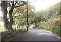
6
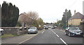
Nantlle village approaching right turn for Llys Alaw
Image: © John Firth
Taken: 22 Oct 2012
0.13 miles
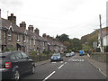
7
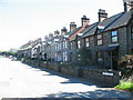
Rhes Victoria Terrace, Nantlle
Every slate quarrying village has its Victoria Terrace. They are invariably well constructed houses built around 1900 for the better off quarrymen and their families.
Image: © Eric Jones
Taken: 8 Sep 2006
0.16 miles
8
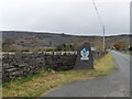
Approaching Nantlle from Talysarn
Some of the villages of Dyffryn Nantlle came into being when quarrying for slate in local quarries began at the end of the 18th century and beginning of the 19th century. The demand for these continued for a century and a half, and although the main quarries have closed there is now considerable call for slate waste to make roads and for garden use.
Image: © Eirian Evans
Taken: 14 Nov 2008
0.17 miles
9
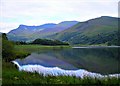
Llyn Nantlle Uchaf
A quiet Sunday morning stroll along the lakeside and a magnificent view.
Snowdon is hidden at the left of the picture.
Image: © Tom Gaunt
Taken: 11 Jul 2010
0.18 miles
10
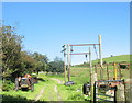
The Gallows and the Tractor
The gallows are used for packing wool sacks. The make of the old tractor is not immediately apparent.
Image: © Eric Jones
Taken: 8 Sep 2006
0.18 miles