IMAGES TAKEN NEAR TO
Clynnogfawr, CAERNARFON, LL54 5PT
Introduction
This page details the photographs taken nearby to LL54 5PT by members of the Geograph project.
The Geograph project started in 2005 with the aim of publishing, organising and preserving representative images for every square kilometre of Great Britain, Ireland and the Isle of Man.

There are currently over 7.5m images from over14,400 individuals and you can help contribute to the project by visiting https://www.geograph.org.uk
Image Map (Loading...)


Getting Data...Please wait
Leaflet Map data © OpenStreetMap
Images are licensed for reuse under creativecommons.org/licenses/by-sa/2.0
Notes
- Clicking on the map will re-center to the selected point.
- The higher the marker number, the further away the image location is from the centre of the postcode.
Image Listing (18 Images Found)
Images are licensed for reuse under creativecommons.org/licenses/by-sa/2.0
Image
Details
Distance
1
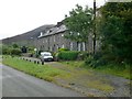
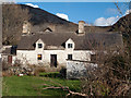
Tan y Graig
Row of quarrymen's cottages at Tan y Graig.
Image: © Eirian Evans
Taken: 18 Aug 2012
0.02 miles
4
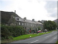
Granite built Tan-y-Graig Terrace
This beautiful terrace of houses on the A499, shortly before the turning for Trefor, dates from the period when the near-by Chwarel y Gwyliwr Quarry on the slope of Gyrn Ddu was at its peak.
Image: © Eric Jones
Taken: 19 Sep 2006
0.07 miles
5
Cefn-buarddau
Cefn-buarddau is a deserted house to the north of Moel-Pen-llechog.
Image: © Trevor Littlewood
Taken: 5 Apr 2008
0.13 miles
6
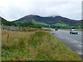
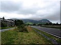
On the Wales Coast Path, near Trefor
Two of the three mountains that overlook Trefor, the one on the left is Tre'r Ceiri and on its summit is the site of Britain's best preserved and possibly the largest remaining Iron Age hill fort.
Image: © Eirian Evans
Taken: 18 Aug 2012
0.14 miles
7
Llanaelhaearn : Gryn Ddu
Looking towards a steep hillside.
Image: © Lewis Clarke
Taken: 19 Apr 2024
0.15 miles
8
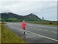
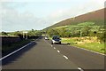
Walking along the Wales Coast Path
Just about to leave the A499 and turn right down to the village of Trefor, which is overlooked by Yr Eifl (the Rivals). The peak on the right has been extensively quarried for granite.
Image: © Eirian Evans
Taken: 18 Aug 2012
0.16 miles
9
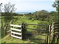
Footpath with gate
The footpath running from Cefn-buarddau to the sea is well-marked at first, and furnished with a fine, new gate at this point. Through the gate there is a sudden drop over a wall, but a set of jutting stones make steps down to ground level.
Image: © Jonathan Wilkins
Taken: 17 Aug 2019
0.16 miles
10
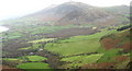
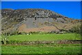
The narrow coastal platform bounded by the Gurn and Eifl hills
This platform is covered by thick deposits of boulder clay which are being eroded by the sea. The heavy clay supports pastoral farming.
Image: © Eric Jones
Taken: 7 Dec 2007
0.18 miles