IMAGES TAKEN NEAR TO
Clynnogfawr, CAERNARFON, LL54 5PG
Introduction
This page details the photographs taken nearby to LL54 5PG by members of the Geograph project.
The Geograph project started in 2005 with the aim of publishing, organising and preserving representative images for every square kilometre of Great Britain, Ireland and the Isle of Man.

There are currently over 7.5m images from over14,400 individuals and you can help contribute to the project by visiting https://www.geograph.org.uk
Image Map (Loading...)


Getting Data...Please wait
Leaflet Map data © OpenStreetMap
Images are licensed for reuse under creativecommons.org/licenses/by-sa/2.0
Notes
- Clicking on the map will re-center to the selected point.
- The higher the marker number, the further away the image location is from the centre of the postcode.
Image Listing (25 Images Found)
Images are licensed for reuse under creativecommons.org/licenses/by-sa/2.0
Image
Details
Distance
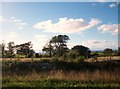
1
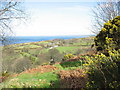
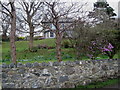
The farmland of Tyddyn Hen from the green lane
Image: © Eric Jones
Taken: 21 Feb 2007
0.01 miles
3
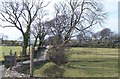
Tyddyn-hen, Gyrn Goch
Tyddyn-hen means "old homestead".
Image: © Eric Jones
Taken: 10 Apr 2010
0.08 miles
6
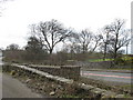
Pontydd y Felin - old and new
'Pontydd' is the plural of 'pont'. The old mill bridge (left) was replaced by an adjoining new one carrying a new stretch of road.
Image: © Eric Jones
Taken: 21 Feb 2007
0.14 miles
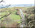
7
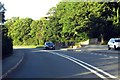
The A499 on Pont y Felin
Pont y Felin carries the A499 over Afon Hen.
Image: © Steve Daniels
Taken: 27 Aug 2015
0.16 miles
8
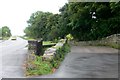
Pont y Felin, Gyrn Goch
The widened A499 on the left and the original road over Pont y Felin on the right.See Image for the view to the west.
Image: © Eirian Evans
Taken: 18 Aug 2012
0.16 miles
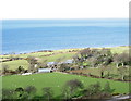
10
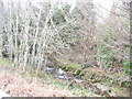
Afon Hen
Here the river flows parallel with the main road.
Image: © Eric Jones
Taken: 21 Feb 2007
0.17 miles