IMAGES TAKEN NEAR TO
Lleuar Terrace, CAERNARFON, LL54 5ES
Introduction
This page details the photographs taken nearby to Lleuar Terrace, LL54 5ES by members of the Geograph project.
The Geograph project started in 2005 with the aim of publishing, organising and preserving representative images for every square kilometre of Great Britain, Ireland and the Isle of Man.

There are currently over 7.5m images from over14,400 individuals and you can help contribute to the project by visiting https://www.geograph.org.uk
Image Map (Loading...)


Getting Data...Please wait
Leaflet Map data © OpenStreetMap
Images are licensed for reuse under creativecommons.org/licenses/by-sa/2.0
Notes
- Clicking on the map will re-center to the selected point.
- The higher the marker number, the further away the image location is from the centre of the postcode.
Image Listing (34 Images Found)
Images are licensed for reuse under creativecommons.org/licenses/by-sa/2.0
Image
Details
Distance
1
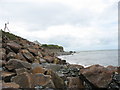
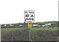
Coastal Defences at Pontllyfni
The boulder clay cliffs are been eroded at a fast pace. Here, where the land threatened is occupied by houses, chalets, and the St Ives Holiday Camp, an attempt has been made to protect the cliffs by building a breakwater of rocks.
Image: © Eric Jones
Taken: 28 Sep 2006
0.04 miles
2
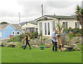
Coastal Defences Surveyors
When asked whether he felt a bit like King Canute, the senior surveyor quipped 'Sometimes, but a bit of Moses as well', indicating with his hands the opening of the Red Sea.
Image: © Eric Jones
Taken: 28 Sep 2006
0.04 miles
3
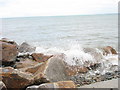
Moderate Sea Waves Breaking Against the Sea Defences
The scene must be spectacular in time of storms
Image: © Eric Jones
Taken: 28 Sep 2006
0.04 miles
5
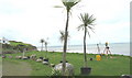
Tropical Island Survey?
Surveyors instruments beneath the palm trees are an indication that not everything is hunky-dory in paradise.
Image: © Eric Jones
Taken: 28 Sep 2006
0.04 miles
7
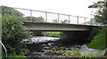
The A499 Pontllyfni Road Bridge
This is the 'pont' in Pontllyfni, and the river flowing beneath it is the Llyfni. It is a modern bridge, and replaced the existing narrow picturesque typical village bridge.
Image: © Eric Jones
Taken: 28 Sep 2006
0.04 miles
8
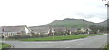
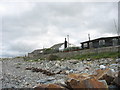
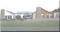
Bungalowland Pontllyfni
The outcome of speculative building primarily for the retirement and holiday home market.
Image: © Eric Jones
Taken: 28 Sep 2006
0.04 miles
10
Bungalows alongside the A499 at Pontllyfni
Image: © Eric Jones
Taken: 13 Feb 2008
0.07 miles