IMAGES TAKEN NEAR TO
Clynnogfawr, CAERNARFON, LL54 5DL
Introduction
This page details the photographs taken nearby to LL54 5DL by members of the Geograph project.
The Geograph project started in 2005 with the aim of publishing, organising and preserving representative images for every square kilometre of Great Britain, Ireland and the Isle of Man.

There are currently over 7.5m images from over14,400 individuals and you can help contribute to the project by visiting https://www.geograph.org.uk
Image Map (Loading...)


Getting Data...Please wait
Leaflet Map data © OpenStreetMap
Images are licensed for reuse under creativecommons.org/licenses/by-sa/2.0
Notes
- Clicking on the map will re-center to the selected point.
- The higher the marker number, the further away the image location is from the centre of the postcode.
Image Listing (3 Images Found)
Images are licensed for reuse under creativecommons.org/licenses/by-sa/2.0
Image
Details
Distance
1
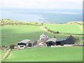
Fferm Brysgyni Uchaf Farm
This pastoral farm lies at the foot of the steep northern slope of Bwlch Mawr.
Image: © Eric Jones
Taken: 25 Sep 2006
0.16 miles
2
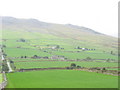
The Reverse View from Pen y Garreg Towards Brysgyni Uchaf Farm
This is the view south over the fields of Fferm Brysgyni Uchaf. In the background are slopes of Bwlch Mawr.
Image: © Eric Jones
Taken: 25 Sep 2006
0.21 miles
3
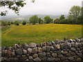
Caeau Tan Y Bwlch
Traditional meadows, managed by the North Wales Wildlife Trust.
Image: © Chris Andrews
Taken: 19 Jun 2015
0.21 miles