IMAGES TAKEN NEAR TO
Clynnogfawr, CAERNARFON, LL54 5DG
Introduction
This page details the photographs taken nearby to LL54 5DG by members of the Geograph project.
The Geograph project started in 2005 with the aim of publishing, organising and preserving representative images for every square kilometre of Great Britain, Ireland and the Isle of Man.

There are currently over 7.5m images from over14,400 individuals and you can help contribute to the project by visiting https://www.geograph.org.uk
Image Map (Loading...)


Getting Data...Please wait
Leaflet Map data © OpenStreetMap
Images are licensed for reuse under creativecommons.org/licenses/by-sa/2.0
Notes
- Clicking on the map will re-center to the selected point.
- The higher the marker number, the further away the image location is from the centre of the postcode.
Image Listing (8 Images Found)
Images are licensed for reuse under creativecommons.org/licenses/by-sa/2.0
Image
Details
Distance
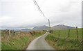
1
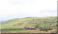
Fferm Bryn Ifan with Y Foel in the background
Image: © Eric Jones
Taken: 2 Mar 2007
0.02 miles
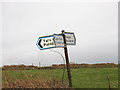
3
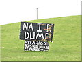
No to the Dump
This is a sign set up by local objectors to a proposal by Cyngor Sir Gwynedd County Council to establish a composting plant next to the Gyfelog Nature Reserve.
The text reads. 'No to the Dump. Meeting 30-5-06 Clynnog Hall 7.00'.
http://news.bbc.co.uk/1/hi/wales/north_west/5031308.stm
Image: © Eric Jones
Taken: 2 Mar 2007
0.15 miles
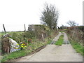
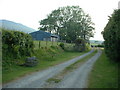
8
Farm boundary between Maesog and Bryn Ifan
Image: © Eric Jones
Taken: 2 Mar 2007
0.24 miles