IMAGES TAKEN NEAR TO
Edern, PWLLHELI, LL53 8YY
Introduction
This page details the photographs taken nearby to LL53 8YY by members of the Geograph project.
The Geograph project started in 2005 with the aim of publishing, organising and preserving representative images for every square kilometre of Great Britain, Ireland and the Isle of Man.

There are currently over 7.5m images from over14,400 individuals and you can help contribute to the project by visiting https://www.geograph.org.uk
Image Map (Loading...)


Getting Data...Please wait
Leaflet Map data © OpenStreetMap
Images are licensed for reuse under creativecommons.org/licenses/by-sa/2.0
Notes
- Clicking on the map will re-center to the selected point.
- The higher the marker number, the further away the image location is from the centre of the postcode.
Image Listing (11 Images Found)
Images are licensed for reuse under creativecommons.org/licenses/by-sa/2.0
Image
Details
Distance
1

Hirdref Isaf Farm
This is also a dairy unit with added income from tourism.
http://www.holidaylettings.co.uk/rentals/morfa-nefyn/70344
Image: © Eric Jones
Taken: 10 Aug 2010
0.02 miles
2

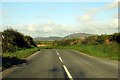
View across farmland towards Hirdre Isaf
Image: © Eric Jones
Taken: 10 Aug 2010
0.03 miles


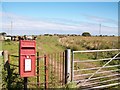
6
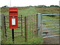
Pillar box and Kiss Gate
Looking NW up the track from the B4417
Image: © Chris Shaw
Taken: 26 Aug 2006
0.11 miles
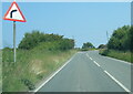
8

Rough grazing land north of the B4417
This one of a relatively few areas of rough grazing in this district.
Image: © Eric Jones
Taken: 10 Aug 2010
0.14 miles
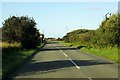
10
The path, the post box, the kissing gate and a herd of cows
The path leads from the kissing gate along the edge of the bog in the direction of the Cwmistir area.
Image: © Eric Jones
Taken: 10 Aug 2010
0.14 miles