IMAGES TAKEN NEAR TO
Boduan, PWLLHELI, LL53 8YH
Introduction
This page details the photographs taken nearby to LL53 8YH by members of the Geograph project.
The Geograph project started in 2005 with the aim of publishing, organising and preserving representative images for every square kilometre of Great Britain, Ireland and the Isle of Man.

There are currently over 7.5m images from over14,400 individuals and you can help contribute to the project by visiting https://www.geograph.org.uk
Image Map (Loading...)


Getting Data...Please wait
Leaflet Map data © OpenStreetMap
Images are licensed for reuse under creativecommons.org/licenses/by-sa/2.0
Notes
- Clicking on the map will re-center to the selected point.
- The higher the marker number, the further away the image location is from the centre of the postcode.
Image Listing (7 Images Found)
Images are licensed for reuse under creativecommons.org/licenses/by-sa/2.0
Image
Details
Distance
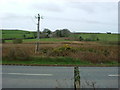
1
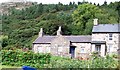
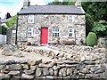
Cottages below the forested Garn Boduan
One has an excellent crop of runner beans.
Image: © Eric Jones
Taken: 10 Aug 2010
0.11 miles
6
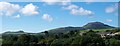
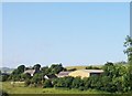
Fferm Tal-y-sarn from the A499
Fferm Tal-y-sarn overlooks the Afon Geirch valley. This image shows a range of hills in the background. These igneous intrusions are, from left to right, Carneddol, Carn Saethon, Garn Bach and Garnfadryn.
Image: © Eric Jones
Taken: 10 Aug 2010
0.20 miles
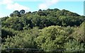
7
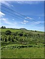
View south-west from the A497
Wooded valley of the River Ceirch, then pasture and Carn Fadryn on the horizon
Image: © Eirian Evans
Taken: 14 Jun 2021
0.22 miles