IMAGES TAKEN NEAR TO
Sarn, PWLLHELI, LL53 8RH
Introduction
This page details the photographs taken nearby to LL53 8RH by members of the Geograph project.
The Geograph project started in 2005 with the aim of publishing, organising and preserving representative images for every square kilometre of Great Britain, Ireland and the Isle of Man.

There are currently over 7.5m images from over14,400 individuals and you can help contribute to the project by visiting https://www.geograph.org.uk
Image Map (Loading...)


Getting Data...Please wait
Leaflet Map data © OpenStreetMap
Images are licensed for reuse under creativecommons.org/licenses/by-sa/2.0
Notes
- Clicking on the map will re-center to the selected point.
- The higher the marker number, the further away the image location is from the centre of the postcode.
Image Listing (7 Images Found)
Images are licensed for reuse under creativecommons.org/licenses/by-sa/2.0
Image
Details
Distance
1
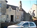
The old part of farmhouse at Trefaes, Botwnnog
The bell cote on the roof is an interesting feature. It was designed to inform farm workers when to start and complete their daily toil in days when few had watches.
Image: © Eric Jones
Taken: 8 Oct 2010
0.01 miles
2
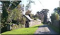
Traditional farm buildings at Trefaes Fawr farm
Image: © Eric Jones
Taken: 8 Oct 2010
0.03 miles
3
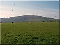
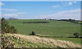
Cultivated grassland at Trefaes Fawr
Mynydd Rhiw forms the background.
Image: © Eric Jones
Taken: 8 Oct 2010
0.14 miles
4
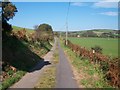
View northwards towards Lon Trefaes Fawr
Trefaes Fawr farm is located just beyond the woodland plantation.
Image: © Eric Jones
Taken: 8 Oct 2010
0.16 miles
6
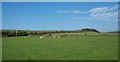
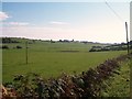
View across the valley floor to grazing sheep at Bronphilip Farm
Image: © Eric Jones
Taken: 8 Oct 2010
0.17 miles
7
View south along the lower section of the Llaniestyn gorge
Image: © Eric Jones
Taken: 8 Oct 2010
0.20 miles