IMAGES TAKEN NEAR TO
Boduan, PWLLHELI, LL53 8PJ
Introduction
This page details the photographs taken nearby to LL53 8PJ by members of the Geograph project.
The Geograph project started in 2005 with the aim of publishing, organising and preserving representative images for every square kilometre of Great Britain, Ireland and the Isle of Man.

There are currently over 7.5m images from over14,400 individuals and you can help contribute to the project by visiting https://www.geograph.org.uk
Image Map
Images are licensed for reuse under creativecommons.org/licenses/by-sa/2.0
Notes
- Clicking on the map will re-center to the selected point.
- The higher the marker number, the further away the image location is from the centre of the postcode.
Image Listing (8 Images Found)
Images are licensed for reuse under creativecommons.org/licenses/by-sa/2.0
Image
Details
Distance
1
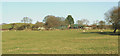
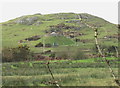
Penmaen-uchaf Farmhouse
Penmaen-uchaf, Llannor, is a mixed crop farm.
Image: © Eric Jones
Taken: 30 Jan 2008
0.11 miles
2
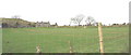
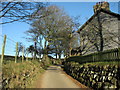
Lane to Penmaen Uchaf
Looking north west. The house is in the adjacent square.
Image: © David Medcalf
Taken: 1 Sep 2006
0.11 miles
3
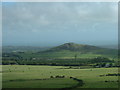
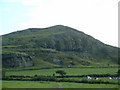
Moelypenmaen
A distant view of this little hill, showing how it stands out in its landscape. Looking south east from Mynydd Nefyn.
Image: © David Medcalf
Taken: 1 Sep 2006
0.19 miles
4
Covered reservoir on the east side of Moelypenmaen
Image: © Eric Jones
Taken: 30 Jan 2008
0.20 miles
6
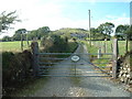
The lane past Gwnhinger
Beyond the house this lane becomes a dirt track.
Image: © Eric Jones
Taken: 19 Dec 2007
0.24 miles
7
Crags on Moelypenmaen
Looking south west.
Image: © David Medcalf
Taken: 1 Sep 2006
0.24 miles