IMAGES TAKEN NEAR TO
Tudweiliog, PWLLHELI, LL53 8PB
Introduction
This page details the photographs taken nearby to LL53 8PB by members of the Geograph project.
The Geograph project started in 2005 with the aim of publishing, organising and preserving representative images for every square kilometre of Great Britain, Ireland and the Isle of Man.

There are currently over 7.5m images from over14,400 individuals and you can help contribute to the project by visiting https://www.geograph.org.uk
Image Map (Loading...)


Getting Data...Please wait
Leaflet Map data © OpenStreetMap
Images are licensed for reuse under creativecommons.org/licenses/by-sa/2.0
Notes
- Clicking on the map will re-center to the selected point.
- The higher the marker number, the further away the image location is from the centre of the postcode.
Image Listing (4 Images Found)
Images are licensed for reuse under creativecommons.org/licenses/by-sa/2.0
Image
Details
Distance
1
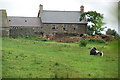
Farm near Pen Y Bryn
This farm stands on the edge of square SH2136, I couldn't see its name.
Image: © Peter Shone
Taken: 6 Oct 2005
0.17 miles
2
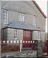
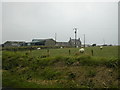
Capel Penllech
Calvinistic Methodist and in an isolated situation. The anchor motifs are an unusual acknowledgment of the area's maritime tradition.
Image: © Dewi
Taken: Unknown
0.19 miles
3
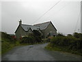
Chapel at Penllech Bach
This chapel at Penllech Bach is unusual in having a house built right into the chapel.
Image: © Peter Shone
Taken: 6 Oct 2005
0.19 miles