IMAGES TAKEN NEAR TO
Llangwnadl, PWLLHELI, LL53 8NT
Introduction
This page details the photographs taken nearby to LL53 8NT by members of the Geograph project.
The Geograph project started in 2005 with the aim of publishing, organising and preserving representative images for every square kilometre of Great Britain, Ireland and the Isle of Man.

There are currently over 7.5m images from over14,400 individuals and you can help contribute to the project by visiting https://www.geograph.org.uk
Image Map (Loading...)


Getting Data...Please wait
Leaflet Map data © OpenStreetMap
Images are licensed for reuse under creativecommons.org/licenses/by-sa/2.0
Notes
- Clicking on the map will re-center to the selected point.
- The higher the marker number, the further away the image location is from the centre of the postcode.
Image Listing (4 Images Found)
Images are licensed for reuse under creativecommons.org/licenses/by-sa/2.0
Image
Details
Distance
2
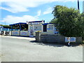
Harbour Way Cafe, Porth Colmon
Near a campsite at Porth Colmon. An ice cream would have been nice ... pity it was closed.
Image: © Eirian Evans
Taken: 18 Jul 2021
0.13 miles
3
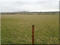
View over farmland from the Coastal Path
Looking towards Morfa. In the distance is Mynydd Cefnamwlch
Image: © Eirian Evans
Taken: 23 Feb 2022
0.15 miles
4
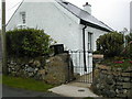
Tyddyn Du near Porth Colmon
This immaculate cottage gives its age away by the size of the tiny upstairs window.
Image: © Peter Shone
Taken: 6 Oct 2005
0.21 miles