IMAGES TAKEN NEAR TO
Tudweiliog, PWLLHELI, LL53 8NB
Introduction
This page details the photographs taken nearby to LL53 8NB by members of the Geograph project.
The Geograph project started in 2005 with the aim of publishing, organising and preserving representative images for every square kilometre of Great Britain, Ireland and the Isle of Man.

There are currently over 7.5m images from over14,400 individuals and you can help contribute to the project by visiting https://www.geograph.org.uk
Image Map (Loading...)


Getting Data...Please wait
Leaflet Map data © OpenStreetMap
Images are licensed for reuse under creativecommons.org/licenses/by-sa/2.0
Notes
- Clicking on the map will re-center to the selected point.
- The higher the marker number, the further away the image location is from the centre of the postcode.
Image Listing (42 Images Found)
Images are licensed for reuse under creativecommons.org/licenses/by-sa/2.0
Image
Details
Distance
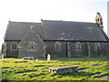
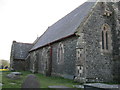
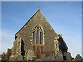
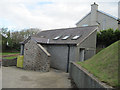
3
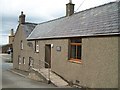
The Community Centre, Tudweiliog
This is locate near St Cwyfan's Church.
Image: © Eric Jones
Taken: 10 Aug 2010
0.05 miles
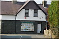
5
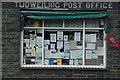
Tudweiliog Post Office
The post office window is crammed with notices of local events and services.
Image: © Stephen McKay
Taken: 24 Aug 2014
0.05 miles
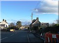
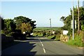
7
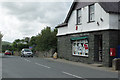
Tudweiliog
Looking along the B4417 through the village with the post office on the right.
Image: © Stephen McKay
Taken: 24 Aug 2014
0.06 miles