IMAGES TAKEN NEAR TO
Rhoshirwaun, PWLLHELI, LL53 8LB
Introduction
This page details the photographs taken nearby to LL53 8LB by members of the Geograph project.
The Geograph project started in 2005 with the aim of publishing, organising and preserving representative images for every square kilometre of Great Britain, Ireland and the Isle of Man.

There are currently over 7.5m images from over14,400 individuals and you can help contribute to the project by visiting https://www.geograph.org.uk
Image Map
Images are licensed for reuse under creativecommons.org/licenses/by-sa/2.0
Notes
- Clicking on the map will re-center to the selected point.
- The higher the marker number, the further away the image location is from the centre of the postcode.
Image Listing (17 Images Found)
Images are licensed for reuse under creativecommons.org/licenses/by-sa/2.0
Image
Details
Distance
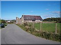
2
Approaching Ysgol Llidiardau school from the north
Image: © Eric Jones
Taken: 25 Sep 2010
0.03 miles
3
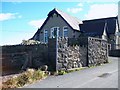
Ysgol Llidiardau, Rhoshirwaun
Ysgol Llidiardau which serves Rhoshirwaen and the surrounding districts has some 50 pupils. Some 98% have Welsh as their first language.
Image: © Eric Jones
Taken: 25 Sep 2010
0.03 miles
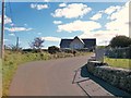
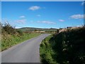
5
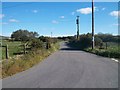
The road linking Ysgol Llidiardau school with the village of Rhoshirwaen
Image: © Eric Jones
Taken: 25 Sep 2010
0.06 miles
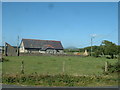
6
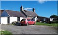
Traditional cottage near Ysgol Llidiardau
Image: © Eric Jones
Taken: 25 Sep 2010
0.09 miles
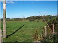
10
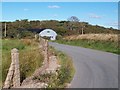
Road bends near Neuadd Rhoshirwaun village hall
Image: © Eric Jones
Taken: 25 Sep 2010
0.16 miles