IMAGES TAKEN NEAR TO
Pentre Uchaf, PWLLHELI, LL53 8EZ
Introduction
This page details the photographs taken nearby to LL53 8EZ by members of the Geograph project.
The Geograph project started in 2005 with the aim of publishing, organising and preserving representative images for every square kilometre of Great Britain, Ireland and the Isle of Man.

There are currently over 7.5m images from over14,400 individuals and you can help contribute to the project by visiting https://www.geograph.org.uk
Image Map
Images are licensed for reuse under creativecommons.org/licenses/by-sa/2.0
Notes
- Clicking on the map will re-center to the selected point.
- The higher the marker number, the further away the image location is from the centre of the postcode.
Image Listing (20 Images Found)
Images are licensed for reuse under creativecommons.org/licenses/by-sa/2.0
Image
Details
Distance
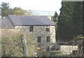
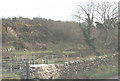
2
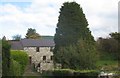
Melin Bodeilian watermill
This mill was powered by water drawn from Afon Rhyd-hir.
Image: © Eric Jones
Taken: 16 Oct 2010
0.02 miles
4
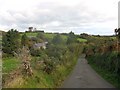
The minor Pistyll-Pentreuchaf road near Melin Bodeilian
Image: © Eric Jones
Taken: 16 Oct 2010
0.03 miles
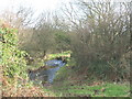
7
View across the Afon Rhyd-hir valley north of Melin Bodeilian
The stream occupies a narrow steep-sided valley.
Image: © Eric Jones
Taken: 30 Jan 2008
0.05 miles
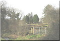
8
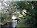
Footbridge over Afon Rhyd-hir south of Melin Bodeilian
This path leads to the Llithfaen-Pentreuchaf road.
Image: © Eric Jones
Taken: 16 Oct 2010
0.06 miles
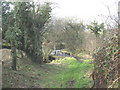
10
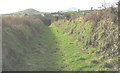
Green lane between Ty Mawr and Melin Bodeilian
This green lane has the status of "other route with public access". The large house in the middleground, backed by Moelypenmaen hill, is Hendre Penprys.
Image: © Eric Jones
Taken: 30 Jan 2008
0.10 miles