IMAGES TAKEN NEAR TO
Pentre Uchaf, PWLLHELI, LL53 8EX
Introduction
This page details the photographs taken nearby to LL53 8EX by members of the Geograph project.
The Geograph project started in 2005 with the aim of publishing, organising and preserving representative images for every square kilometre of Great Britain, Ireland and the Isle of Man.

There are currently over 7.5m images from over14,400 individuals and you can help contribute to the project by visiting https://www.geograph.org.uk
Image Map (Loading...)


Getting Data...Please wait
Leaflet Map data © OpenStreetMap
Images are licensed for reuse under creativecommons.org/licenses/by-sa/2.0
Notes
- Clicking on the map will re-center to the selected point.
- The higher the marker number, the further away the image location is from the centre of the postcode.
Image Listing (8 Images Found)
Images are licensed for reuse under creativecommons.org/licenses/by-sa/2.0
Image
Details
Distance
1
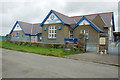
Ysgol Gynradd Pentreuchaf Primary School
One of many schools in the area built in 1908, following the Liberal Government's Education Acts. The extension on the left was opened in 2004.
Image: © Alan Fryer
Taken: 27 Jul 2007
0.18 miles
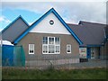
2
Ysgol Gynradd Pentreuchaf Primary School
see Image
Image: © Alan Fryer
Taken: 27 Jul 2007
0.19 miles
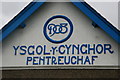
3
Ysgol Gynradd Pentreuchaf Primary School
Ysgol Pentreuchaf, housed in a building that is well over a hundred years old is situated deep in the countryside and serves the communities of Llithfaen, Boduan and Pentreuchaf. Some 90 percent of the children have Welsh as their first/only language. English is not formally taught in Key Stage 1.
Image: © Eric Jones
Taken: 16 Oct 2010
0.21 miles
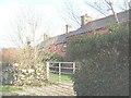
4
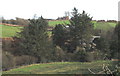
Hill slope above Melin Bodeilian
The house at the top of the slope is Ty Mawr. Melin Bodeilian is partially hidden by the enormous trees.
Image: © Eric Jones
Taken: 30 Jan 2008
0.21 miles
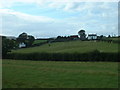
5
Green lane between Ty Mawr and Melin Bodeilian
This green lane has the status of "other route with public access". The large house in the middleground, backed by Moelypenmaen hill, is Hendre Penprys.
Image: © Eric Jones
Taken: 30 Jan 2008
0.22 miles
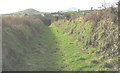
7
Fron
That's the name of the white house, centre right. Looking north west.
Image: © David Medcalf
Taken: 1 Sep 2006
0.24 miles
8
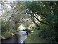
Footbridge over Afon Rhyd-hir south of Melin Bodeilian
This path leads to the Llithfaen-Pentreuchaf road.
Image: © Eric Jones
Taken: 16 Oct 2010
0.25 miles