IMAGES TAKEN NEAR TO
Sarn, PWLLHELI, LL53 8EA
Introduction
This page details the photographs taken nearby to LL53 8EA by members of the Geograph project.
The Geograph project started in 2005 with the aim of publishing, organising and preserving representative images for every square kilometre of Great Britain, Ireland and the Isle of Man.

There are currently over 7.5m images from over14,400 individuals and you can help contribute to the project by visiting https://www.geograph.org.uk
Image Map (Loading...)


Getting Data...Please wait
Leaflet Map data © OpenStreetMap
Images are licensed for reuse under creativecommons.org/licenses/by-sa/2.0
Notes
- Clicking on the map will re-center to the selected point.
- The higher the marker number, the further away the image location is from the centre of the postcode.
Image Listing (22 Images Found)
Images are licensed for reuse under creativecommons.org/licenses/by-sa/2.0
Image
Details
Distance
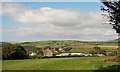
4
Efail Uchaf, Sarn
Efail Uchaf means "upper smithy"
Image: © Eric Jones
Taken: 14 Aug 2010
0.08 miles
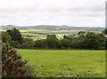
5
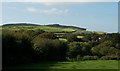
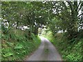
Woodland below Ty'n-y-coed
Ty'n-y-coed means "farmstead in the woods". Mynydd Cefnamwlch forms the background with the improved cattle pastures a prominent feature of the hill.
Image: © Eric Jones
Taken: 14 Aug 2010
0.09 miles
6
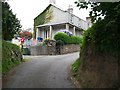
Terrace of houses on the backroad to Bryncroes
The name Pretoria Terrace gives a clue to when these houses were built.
Image: © Eric Jones
Taken: 14 Aug 2010
0.11 miles
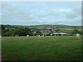
9
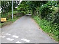
The road uphill towards Mynydd Rhiw
The MOD radio mast on the summit is plainly visible.
Image: © Eric Jones
Taken: 14 Aug 2010
0.14 miles
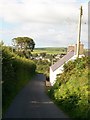
10
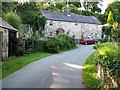
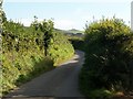
Bend of a tree lined section of the lane to Bryncroes
Image: © Eric Jones
Taken: 14 Aug 2010
0.15 miles