IMAGES TAKEN NEAR TO
Nanhoron, PWLLHELI, LL53 7YA
Introduction
This page details the photographs taken nearby to LL53 7YA by members of the Geograph project.
The Geograph project started in 2005 with the aim of publishing, organising and preserving representative images for every square kilometre of Great Britain, Ireland and the Isle of Man.

There are currently over 7.5m images from over14,400 individuals and you can help contribute to the project by visiting https://www.geograph.org.uk
Image Map (Loading...)


Getting Data...Please wait
Leaflet Map data © OpenStreetMap
Images are licensed for reuse under creativecommons.org/licenses/by-sa/2.0
Notes
- Clicking on the map will re-center to the selected point.
- The higher the marker number, the further away the image location is from the centre of the postcode.
Image Listing (12 Images Found)
Images are licensed for reuse under creativecommons.org/licenses/by-sa/2.0
Image
Details
Distance
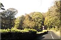
2
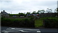
Bodlondeb from the road
Interesting old buildings here.
Image: © Jeremy Bolwell
Taken: 25 May 2015
0.11 miles
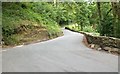
3
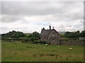
Bodlondeb farmhouse, Nanhoron
Bodlondeb in Welsh means "contentment".
Image: © Eric Jones
Taken: 14 Aug 2010
0.12 miles
4
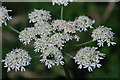
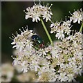
Cleren ar flodyn - A fly on a flower
The flower is Hogweed (Heracleum sphondylium)
Image: © Alan Fryer
Taken: 29 Jul 2007
0.13 miles
5
Cleren ar flodyn - A fly on a flower
The flower is Hogweed (Heracleum sphondylium)
Image: © Alan Fryer
Taken: 28 Jul 2007
0.13 miles

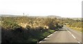
7
Gwinllan Cae-garw
Gwinllan Cae-garw means "rough-field grove". This image is taken from the B4413.
Image: © Eric Jones
Taken: 27 Oct 2010
0.15 miles
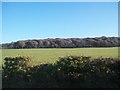
10
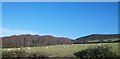
The Gwinllan Cae-garw woodland with Mynytho Common in the background
Image: © Eric Jones
Taken: 27 Oct 2010
0.24 miles