IMAGES TAKEN NEAR TO
Mynytho, PWLLHELI, LL53 7UF
Introduction
This page details the photographs taken nearby to LL53 7UF by members of the Geograph project.
The Geograph project started in 2005 with the aim of publishing, organising and preserving representative images for every square kilometre of Great Britain, Ireland and the Isle of Man.

There are currently over 7.5m images from over14,400 individuals and you can help contribute to the project by visiting https://www.geograph.org.uk
Image Map (Loading...)


Getting Data...Please wait
Leaflet Map data © OpenStreetMap
Images are licensed for reuse under creativecommons.org/licenses/by-sa/2.0
Notes
- Clicking on the map will re-center to the selected point.
- The higher the marker number, the further away the image location is from the centre of the postcode.
Image Listing (12 Images Found)
Images are licensed for reuse under creativecommons.org/licenses/by-sa/2.0
Image
Details
Distance

2
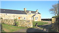
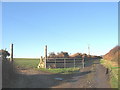
Fferm y Muriau Farm
Muriau is a pastoral unit, rearing sheep and beef cattle.
The old dog came out to greet me as I passed, and when he saw the camera he returned inside the gate and sat down to pose for a photo.
Image: © Eric Jones
Taken: 21 Dec 2007
0.01 miles
3
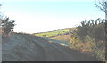
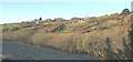
View south across waste land towards the Oerddwr valley
The bracken infested wasteland is an area with open access status. The Oerddwr valley, a glacial meltwater channel, is occupied by a misfit stream.
Image: © Eric Jones
Taken: 21 Dec 2007
0.10 miles
4
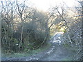
A frozen, muddy, track near Oerddwr cottage
Image: © Eric Jones
Taken: 21 Dec 2007
0.19 miles
6
Meltwater channel west of Oerddwr cottage
Image: © Eric Jones
Taken: 21 Dec 2007
0.20 miles
7
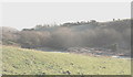
A meltwater channel east of Oerddwr
This one of a number of such channels in this area formed when supraglacial and subglacial meltwaters (i.e. flowing on the surface of and below the ice) from the retreating Irish Sea ice sheet cut their way eastwards through the resistant hill country west of the Hell's Mouth lowlands during the latter stages of the Devensian Glaciation.
Image: © Eric Jones
Taken: 21 Dec 2007
0.21 miles
8
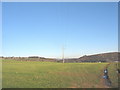
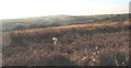
Cultivated grassland south of Muriau
The field is crossed by a branch of the 11Kv powerline.
Image
Image: © Eric Jones
Taken: 21 Dec 2007
0.22 miles
9
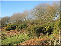
Gorse, bracken and thorns on the rim of the meltwater channel
Image: © Eric Jones
Taken: 21 Dec 2007
0.22 miles