IMAGES TAKEN NEAR TO
Mynytho, PWLLHELI, LL53 7SN
Introduction
This page details the photographs taken nearby to LL53 7SN by members of the Geograph project.
The Geograph project started in 2005 with the aim of publishing, organising and preserving representative images for every square kilometre of Great Britain, Ireland and the Isle of Man.

There are currently over 7.5m images from over14,400 individuals and you can help contribute to the project by visiting https://www.geograph.org.uk
Image Map (Loading...)


Getting Data...Please wait
Leaflet Map data © OpenStreetMap
Images are licensed for reuse under creativecommons.org/licenses/by-sa/2.0
Notes
- Clicking on the map will re-center to the selected point.
- The higher the marker number, the further away the image location is from the centre of the postcode.
Image Listing (5 Images Found)
Images are licensed for reuse under creativecommons.org/licenses/by-sa/2.0
Image
Details
Distance
1

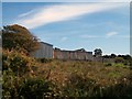
Engan-gam, Mynytho
A part of this property has been converted into self-catering holiday accommodation,
http://www.walesdirectory.co.uk/holiday-cottages2/WALES1232.htm
Image: © Eric Jones
Taken: 1 Sep 2010
0.02 miles
2
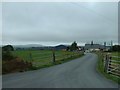
Yr-ynys farm
Looking north west. This farm hosts a number of businesses - feed merchant, timber merchant, building supplies....
Image: © David Medcalf
Taken: 22 Aug 2006
0.07 miles
3
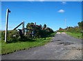
Footpath leading to Capel Newydd, Nanhoron
Image: © Eric Jones
Taken: 25 Sep 2010
0.19 miles