IMAGES TAKEN NEAR TO
Pen Y Bryn Estate, PWLLHELI, LL53 7SE
Introduction
This page details the photographs taken nearby to Pen Y Bryn Estate, LL53 7SE by members of the Geograph project.
The Geograph project started in 2005 with the aim of publishing, organising and preserving representative images for every square kilometre of Great Britain, Ireland and the Isle of Man.

There are currently over 7.5m images from over14,400 individuals and you can help contribute to the project by visiting https://www.geograph.org.uk
Image Map
Images are licensed for reuse under creativecommons.org/licenses/by-sa/2.0
Notes
- Clicking on the map will re-center to the selected point.
- The higher the marker number, the further away the image location is from the centre of the postcode.
Image Listing (28 Images Found)
Images are licensed for reuse under creativecommons.org/licenses/by-sa/2.0
Image
Details
Distance
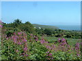
2
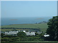
Mynytho
Looking south east over St Tudwal's East & West islands.
Image: © David Medcalf
Taken: 13 Jul 2006
0.06 miles
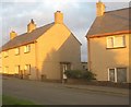
4
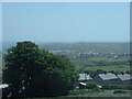
Mynytho
Looking south, over Abersoch.
Image: © David Medcalf
Taken: 13 Jul 2006
0.07 miles
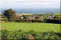
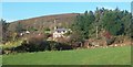
5
Looking over houses in Mynytho towards Abersoch
Image: © David Gearing
Taken: 11 Aug 2010
0.08 miles
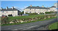
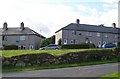
6
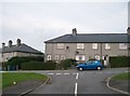
Stad Parciau, Mynytho
These are local authority built houses.
Image: © Eric Jones
Taken: 2 Oct 2010
0.10 miles
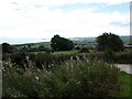
7
Farmland at Mynytho
Looking east towards Mynydd Tir-y-Cwmwd.
Image: © David Medcalf
Taken: 13 Jul 2006
0.10 miles