IMAGES TAKEN NEAR TO
Mynytho, PWLLHELI, LL53 7PR
Introduction
This page details the photographs taken nearby to LL53 7PR by members of the Geograph project.
The Geograph project started in 2005 with the aim of publishing, organising and preserving representative images for every square kilometre of Great Britain, Ireland and the Isle of Man.

There are currently over 7.5m images from over14,400 individuals and you can help contribute to the project by visiting https://www.geograph.org.uk
Image Map
Images are licensed for reuse under creativecommons.org/licenses/by-sa/2.0
Notes
- Clicking on the map will re-center to the selected point.
- The higher the marker number, the further away the image location is from the centre of the postcode.
Image Listing (4 Images Found)
Images are licensed for reuse under creativecommons.org/licenses/by-sa/2.0
Image
Details
Distance
2
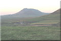
Bwlch-y-mynydd Farm from Foel Fawr
Bwlch-y-mynydd means "mountain col". The imposing mountain in the background is Garn Fadryn.
Image: © Eric Jones
Taken: 21 Dec 2007
0.15 miles
3
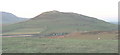
View across the summit of Foel Fawr towards Bwlch-y-mynydd and the slopes of Carneddol
Image: © Eric Jones
Taken: 21 Dec 2007
0.16 miles
4
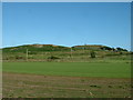
Foel Fawr and old windmill
Looking south east.
Image: © David Medcalf
Taken: 13 Jul 2006
0.19 miles