IMAGES TAKEN NEAR TO
Rhydyclafdy, PWLLHELI, LL53 7PL
Introduction
This page details the photographs taken nearby to LL53 7PL by members of the Geograph project.
The Geograph project started in 2005 with the aim of publishing, organising and preserving representative images for every square kilometre of Great Britain, Ireland and the Isle of Man.

There are currently over 7.5m images from over14,400 individuals and you can help contribute to the project by visiting https://www.geograph.org.uk
Image Map (Loading...)


Getting Data...Please wait
Leaflet Map data © OpenStreetMap
Images are licensed for reuse under creativecommons.org/licenses/by-sa/2.0
Notes
- Clicking on the map will re-center to the selected point.
- The higher the marker number, the further away the image location is from the centre of the postcode.
Image Listing (10 Images Found)
Images are licensed for reuse under creativecommons.org/licenses/by-sa/2.0
Image
Details
Distance
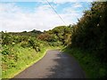
2
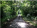
Declivity to the Nant y golchi valley floor on the Ty-isaf road
Image: © Eric Jones
Taken: 31 Jul 2010
0.09 miles
3
View back towards the floor of the valley
Image: © Eric Jones
Taken: 31 Jul 2010
0.10 miles
4
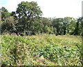
Woodland and bracken on the valley floor
Image: © Eric Jones
Taken: 31 Jul 2010
0.10 miles
5
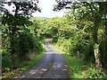
Lon Rhyd-y-clafdy north of the junction with Lon Pin
Image: © Eric Jones
Taken: 31 Jul 2010
0.11 miles
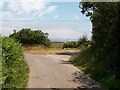
6
Minor road junction below Beudy Mawr
The road to the right - the Llanbedrog road is temporarily closed to traffic.
Image: © Eric Jones
Taken: 25 Jun 2010
0.17 miles
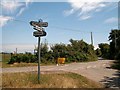
7
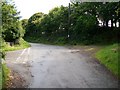
The parting of the ways
The road to the left goes on to Rhyd-y-clafdy, that on the right to Llanbedrog.
Image: © Eric Jones
Taken: 25 Jun 2010
0.17 miles

9
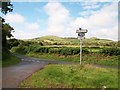
The junction of Lon Pin and Lon Rhyd-y-clafdy
Carneddol and Carn Saethon provide the background.
Image: © Eric Jones
Taken: 31 Jul 2010
0.18 miles
