IMAGES TAKEN NEAR TO
Llanengan, PWLLHELI, LL53 7LG
Introduction
This page details the photographs taken nearby to LL53 7LG by members of the Geograph project.
The Geograph project started in 2005 with the aim of publishing, organising and preserving representative images for every square kilometre of Great Britain, Ireland and the Isle of Man.

There are currently over 7.5m images from over14,400 individuals and you can help contribute to the project by visiting https://www.geograph.org.uk
Image Map
Images are licensed for reuse under creativecommons.org/licenses/by-sa/2.0
Notes
- Clicking on the map will re-center to the selected point.
- The higher the marker number, the further away the image location is from the centre of the postcode.
Image Listing (11 Images Found)
Images are licensed for reuse under creativecommons.org/licenses/by-sa/2.0
Image
Details
Distance
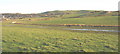
1
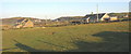
Houses at Ty'n Morfa
These houses occupy a dry site above the Soch floodplain.
Image: © Eric Jones
Taken: 21 Dec 2007
0.02 miles
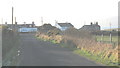
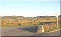
2
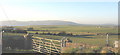
The site of the former RAF Hell's Mouth from the Llanengan road
RAF Porth Neigwl/Hell's Mouth was a bombing and air gunnery training school. Little evidence now remains of this former WWII base.
http://www.thegilbys.org.uk/john/hm/hmhome.html
Image: © Eric Jones
Taken: 21 Dec 2007
0.13 miles
3
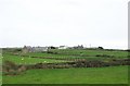
Houses at Tai Morfa
Tai Morfa means "seamarsh houses".
Image: © Eric Jones
Taken: 2 Oct 2010
0.14 miles
4
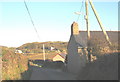
Glanmorfa and Ty'n Llwyn on the road between Porth Neigwl and Llanengan
Image: © Eric Jones
Taken: 21 Dec 2007
0.14 miles
5
On path between Pont Towyn & Cefn - footbridge over un-named stream
Image: © Colin Park
Taken: 2 Jul 2022
0.19 miles
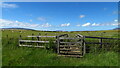
8
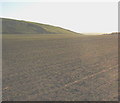
An extensive ploughed field south of Llanengan village
Image: © Eric Jones
Taken: 21 Dec 2007
0.20 miles
10
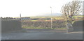
Ty-cerrig from the Sun
This is view westwards across farmland towards Ty-cerrig (=stone house) from the carpark of the Sun Inn.
Image: © Eric Jones
Taken: 21 Dec 2007
0.22 miles