IMAGES TAKEN NEAR TO
Abersoch, PWLLHELI, LL53 7LD
Introduction
This page details the photographs taken nearby to LL53 7LD by members of the Geograph project.
The Geograph project started in 2005 with the aim of publishing, organising and preserving representative images for every square kilometre of Great Britain, Ireland and the Isle of Man.

There are currently over 7.5m images from over14,400 individuals and you can help contribute to the project by visiting https://www.geograph.org.uk
Image Map (Loading...)


Getting Data...Please wait
Leaflet Map data © OpenStreetMap
Images are licensed for reuse under creativecommons.org/licenses/by-sa/2.0
Notes
- Clicking on the map will re-center to the selected point.
- The higher the marker number, the further away the image location is from the centre of the postcode.
Image Listing (5 Images Found)
Images are licensed for reuse under creativecommons.org/licenses/by-sa/2.0
Image
Details
Distance

2
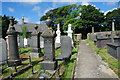
Mynwent Capel y Bwlch Llanengan Capel y Bwlch Graveyard
The Chapel was demolished in the 1980s and stood behind the building in the background, which is the vestry of Capel y Bwlch. The large graveyard is still in use.
Thanks to Philip Jordan of Australia for the information.
Image: © Alan Fryer
Taken: 8 Aug 2007
0.18 miles
3
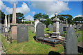
Mynwent Capel y Bwlch a'r hen felin wynt - Capel y Bwlch graveyard and the old windmill
The ruined windmill is at SH297275
Image: © Alan Fryer
Taken: 8 Aug 2007
0.19 miles
4
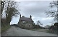
Ty Capel Bwlch
Former minister's house for Bwlch Chapel which is situated just behind this house.
Image: © Eirian Evans
Taken: 23 Feb 2022
0.20 miles
5
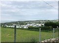
Former farmland at Bwlchtocyn
Now seem to be a breeding ground for caravans. Just south of Abersoch.
Image: © Eirian Evans
Taken: 11 Jun 2021
0.22 miles