IMAGES TAKEN NEAR TO
Chwilog, PWLLHELI, LL53 6TQ
Introduction
This page details the photographs taken nearby to LL53 6TQ by members of the Geograph project.
The Geograph project started in 2005 with the aim of publishing, organising and preserving representative images for every square kilometre of Great Britain, Ireland and the Isle of Man.

There are currently over 7.5m images from over14,400 individuals and you can help contribute to the project by visiting https://www.geograph.org.uk
Image Map
Images are licensed for reuse under creativecommons.org/licenses/by-sa/2.0
Notes
- Clicking on the map will re-center to the selected point.
- The higher the marker number, the further away the image location is from the centre of the postcode.
Image Listing (4 Images Found)
Images are licensed for reuse under creativecommons.org/licenses/by-sa/2.0
Image
Details
Distance
1
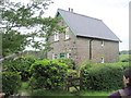
Railway cottage?
Situated alongside the long-disused Afon Wen railway, it seems likely that this was the crossing-keeper's cottage.
Image: © David Medcalf
Taken: 21 Jun 2012
0.09 miles
2
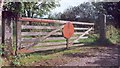
Old crossing gate
One of the level crossing gates where the line from Caernarfon to Afon Wen crossed the Lon Goed. The line was closed by Beeching in the 1960s.
Image: © Dewi
Taken: Unknown
0.10 miles
3
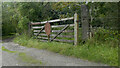
Croesfan rheilffordd / Level crossing
Where Lon Goed crossed the Bangor to Afonwen railway.
Image: © Ceri Thomas
Taken: 28 Aug 2022
0.11 miles
4
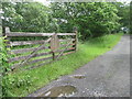
Time is not being kind to the old gate
See: http://www.geograph.org.uk/photo/349290
Image: © David Medcalf
Taken: 21 Jun 2012
0.12 miles