IMAGES TAKEN NEAR TO
Chwilog, PWLLHELI, LL53 6TJ
Introduction
This page details the photographs taken nearby to LL53 6TJ by members of the Geograph project.
The Geograph project started in 2005 with the aim of publishing, organising and preserving representative images for every square kilometre of Great Britain, Ireland and the Isle of Man.

There are currently over 7.5m images from over14,400 individuals and you can help contribute to the project by visiting https://www.geograph.org.uk
Image Map
Images are licensed for reuse under creativecommons.org/licenses/by-sa/2.0
Notes
- Clicking on the map will re-center to the selected point.
- The higher the marker number, the further away the image location is from the centre of the postcode.
Image Listing (4 Images Found)
Images are licensed for reuse under creativecommons.org/licenses/by-sa/2.0
Image
Details
Distance
2
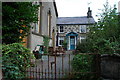
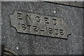
Capel a Thŷ Capel Engedi Chapel and Chapel House
See Image
Image: © Alan Fryer
Taken: 8 Sep 2008
0.21 miles
3
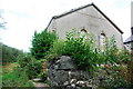
Capel Engedi
Now disused, this large chapel stands in an isolated position in the countryside of Eifionydd, though presumably when it was built the farm tracks which cross here were as much used as the surrounding narrow lanes.
The chapel house is still occupied.
Image: © Alan Fryer
Taken: 8 Sep 2008
0.22 miles
4
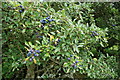
Eirin Tagu - Sloes
After a poor 2008, this year looks to have produced a much better crop.
Image: © Alan Fryer
Taken: 29 Aug 2009
0.25 miles