IMAGES TAKEN NEAR TO
Chwilog, PWLLHELI, LL53 6SD
Introduction
This page details the photographs taken nearby to LL53 6SD by members of the Geograph project.
The Geograph project started in 2005 with the aim of publishing, organising and preserving representative images for every square kilometre of Great Britain, Ireland and the Isle of Man.

There are currently over 7.5m images from over14,400 individuals and you can help contribute to the project by visiting https://www.geograph.org.uk
Image Map (Loading...)


Getting Data...Please wait
Leaflet Map data © OpenStreetMap
Images are licensed for reuse under creativecommons.org/licenses/by-sa/2.0
Notes
- Clicking on the map will re-center to the selected point.
- The higher the marker number, the further away the image location is from the centre of the postcode.
Image Listing (9 Images Found)
Images are licensed for reuse under creativecommons.org/licenses/by-sa/2.0
Image
Details
Distance
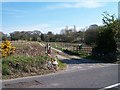
1
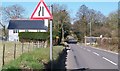
The B4354 narrowing at Pont Cefn Hendre bridge
Here the road crosses a tributary of Afon Erch.
Image: © Eric Jones
Taken: 23 Apr 2010
0.02 miles
5
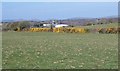
View north-westwards across pastureland in the direction of the South Caernarfon Creameries
Image: © Eric Jones
Taken: 23 Apr 2010
0.15 miles
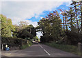
6
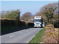
Heavy vehicles on a narrow section of the B4354
The B4354 road is best avoided by walkers and cyclists.
Image: © Eric Jones
Taken: 23 Apr 2010
0.17 miles
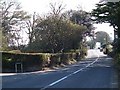
7
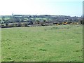
View across sheep grazings towards Plas Newydd farm
Image: © Eric Jones
Taken: 23 Apr 2010
0.17 miles
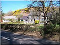
9
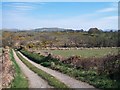
Farm road to Bryn Penrhyn
Glyn Coed farm can be seen in the middleground right backed by Carn Pentyrch hill.
Image: © Eric Jones
Taken: 23 Apr 2010
0.24 miles