IMAGES TAKEN NEAR TO
Llithfaen, PWLLHELI, LL53 6NH
Introduction
This page details the photographs taken nearby to LL53 6NH by members of the Geograph project.
The Geograph project started in 2005 with the aim of publishing, organising and preserving representative images for every square kilometre of Great Britain, Ireland and the Isle of Man.

There are currently over 7.5m images from over14,400 individuals and you can help contribute to the project by visiting https://www.geograph.org.uk
Image Map (Loading...)


Getting Data...Please wait
Leaflet Map data © OpenStreetMap
Images are licensed for reuse under creativecommons.org/licenses/by-sa/2.0
Notes
- Clicking on the map will re-center to the selected point.
- The higher the marker number, the further away the image location is from the centre of the postcode.
Image Listing (14 Images Found)
Images are licensed for reuse under creativecommons.org/licenses/by-sa/2.0
Image
Details
Distance
1
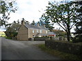
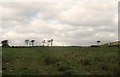
Ffermdy Bryn Celyn Isaf farmhouse
Bryn Celyn Isaf means "lower holly hill".
Image: © Eric Jones
Taken: 16 Oct 2010
0.03 miles
2
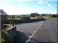
The entrance to Organic Parc at Carguwch Bach
Image: © Eric Jones
Taken: 16 Oct 2010
0.14 miles
3
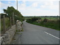
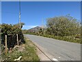
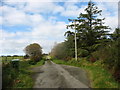
Ffordd i Garnguwch - Road to Carnguwch
Leading to Melin Carnguwch and Carnguwch Bach (Organig Parc)
Image: © Alan Fryer
Taken: 19 Sep 2015
0.14 miles
4
The access lane to the Organig Parc at Carnguwch Bach
Organig Parc is a combination of working farm, luxury holiday accommodation and fishery.
http://www.organigparc.co.uk/home.aspx
Image: © Eric Jones
Taken: 16 Oct 2010
0.14 miles
7
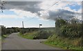
The sign posted entrance to the Gwynus Byway
This is the first such sign posted byway that I have encountered in Gwynedd. The following link outlines the various types of public rights of way and the restrictions applied to each.
http://www.gwynedd.gov.uk/upload/public/attachments/954/webpublicfootpathsetc280808.pdf
Image: © Eric Jones
Taken: 16 Oct 2010
0.21 miles
8
Gwyniasa farmhouse viewed across farmland
Image: © Eric Jones
Taken: 16 Oct 2010
0.22 miles
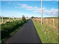
10
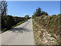
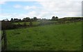
The byway towards Gwynus
The byway is a metalled road at the eastern end, and just grass at the west end. It is a good cycle route connecting minor roads.
Image: © David Medcalf
Taken: 25 Apr 2021
0.23 miles