IMAGES TAKEN NEAR TO
Llwyndyrys, Y Ffor, PWLLHELI, LL53 6NG
Introduction
This page details the photographs taken nearby to LL53 6NG by members of the Geograph project.
The Geograph project started in 2005 with the aim of publishing, organising and preserving representative images for every square kilometre of Great Britain, Ireland and the Isle of Man.

There are currently over 7.5m images from over14,400 individuals and you can help contribute to the project by visiting https://www.geograph.org.uk
Image Map (Loading...)


Getting Data...Please wait
Leaflet Map data © OpenStreetMap
Images are licensed for reuse under creativecommons.org/licenses/by-sa/2.0
Notes
- Clicking on the map will re-center to the selected point.
- The higher the marker number, the further away the image location is from the centre of the postcode.
Image Listing (15 Images Found)
Images are licensed for reuse under creativecommons.org/licenses/by-sa/2.0
Image
Details
Distance
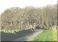
4
Woodlands for sale - Coed Mynydd-mawr
This block of mixed woodlands is former Forestry Commission land. It amounts to 24ha.in area.
Image: © Eric Jones
Taken: 30 Jan 2008
0.12 miles
6
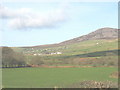
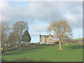
View north across farmland from Llwyndyrys
The large group of buildings in the middleground are at Carnguwch Bach Farm
Image: © Eric Jones
Taken: 30 Jan 2008
0.17 miles
7
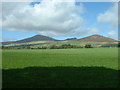
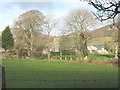
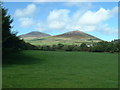
Farmland at Tyddyn Cestyll
Looking north, towards Yr Eifl and Mynydd Carnguwch.
Image: © David Medcalf
Taken: 1 Sep 2006
0.17 miles
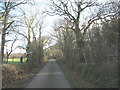
8
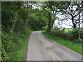
Tractor and trailer on the road west of Llwyndyrys
This narrow country road links the A499 (Caernarfon-Pwllheli road) with the wider unclassified Llithfaen to Efailnewydd road. Most of the traffic encountered on this road was agricultural.
Image: © Eric Jones
Taken: 30 Jan 2008
0.21 miles
9
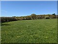
Farmland at Llwyndyrys
Looking north towards Mynydd Carnguwch, with Yr Eifl visible beyond.
Image: © David Medcalf
Taken: 1 Sep 2006
0.21 miles
10
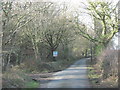
Missing byway
According to the OS map (and Gwynedd Council Definitive Map), a restricted byway follows the line of the hedge. It doesn't, and there is no way through to join the farm lane near the large tree in the centre of the photo.
Image: © David Medcalf
Taken: 25 Apr 2021
0.22 miles