IMAGES TAKEN NEAR TO
Pistyll, PWLLHELI, LL53 6LW
Introduction
This page details the photographs taken nearby to LL53 6LW by members of the Geograph project.
The Geograph project started in 2005 with the aim of publishing, organising and preserving representative images for every square kilometre of Great Britain, Ireland and the Isle of Man.

There are currently over 7.5m images from over14,400 individuals and you can help contribute to the project by visiting https://www.geograph.org.uk
Image Map (Loading...)


Getting Data...Please wait
Leaflet Map data © OpenStreetMap
Images are licensed for reuse under creativecommons.org/licenses/by-sa/2.0
Notes
- Clicking on the map will re-center to the selected point.
- The higher the marker number, the further away the image location is from the centre of the postcode.
Image Listing (9 Images Found)
Images are licensed for reuse under creativecommons.org/licenses/by-sa/2.0
Image
Details
Distance
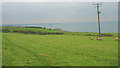
1
Ty Mawr Farm and Caravan Park
In the 1881 census Ty Mawr was recorded as 50 acre farm.
Image: © Eric Jones
Taken: 14 Dec 2007
0.12 miles
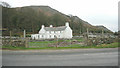
2
Bodeilias the boyhood home of Tom Nefyn
Tom Nefyn, quarryman, soldier, preacher and street corner evangelist was brought up at Bodeilias (occ. spelt Bodeilas), then a 24 acre smallholding. Born in 1895 he worked from a young age in the local granite quarry before serving with the RWFs in Gallipoli and Palestine. Influenced by an army chaplain he entered the Calvinistic Methodist ministry but soon ran into trouble because of his controversial socialist and doctrinal views. Image
Image: © Eric Jones
Taken: 14 Dec 2007
0.13 miles
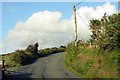
4
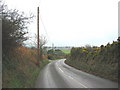
A bend on the B4417 Pistyll to Nefyn road
Image: © Eric Jones
Taken: 14 Dec 2007
0.16 miles
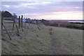
5

The B4417 west of Pistyll
The bus-stop sign opposite the houses is obscured by ivy
Image: © Eirian Evans
Taken: 17 Jul 2021
0.17 miles
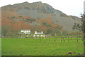
7
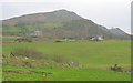
Cottages in the shadow of Y Gwylwyr hill
Image: © Eric Jones
Taken: 14 Dec 2007
0.22 miles