IMAGES TAKEN NEAR TO
Glan Y Pwll, PWLLHELI, LL53 6EH
Introduction
This page details the photographs taken nearby to Glan Y Pwll, LL53 6EH by members of the Geograph project.
The Geograph project started in 2005 with the aim of publishing, organising and preserving representative images for every square kilometre of Great Britain, Ireland and the Isle of Man.

There are currently over 7.5m images from over14,400 individuals and you can help contribute to the project by visiting https://www.geograph.org.uk
Image Map (Loading...)


Getting Data...Please wait
Leaflet Map data © OpenStreetMap
Images are licensed for reuse under creativecommons.org/licenses/by-sa/2.0
Notes
- Clicking on the map will re-center to the selected point.
- The higher the marker number, the further away the image location is from the centre of the postcode.
Image Listing (78 Images Found)
Images are licensed for reuse under creativecommons.org/licenses/by-sa/2.0
Image
Details
Distance
1
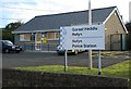
Gorsaf Heddlu wedi'i Fandaleiddio - Police Station Vandalised
The new police station at Nefyn is not permanently staffed. Over the Christmas period 2007 all its windows were smashed. Local residents are right to be alarmed. See http://news.bbc.co.uk/1/hi/wales/north_west/7161509.stm
Image: © Alan Fryer
Taken: 6 Jan 2008
0.07 miles
3
Cliff top houses on the western outskirts of Nefyn
This view is taken from the cliff top path.
Image: © Eric Jones
Taken: 19 Dec 2007
0.09 miles
4
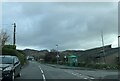
Bus shelter on the B4417 at Nefyn
The premises of the Dwyfor Coffee Company behind it
Image: © Eirian Evans
Taken: 24 Feb 2022
0.09 miles
5
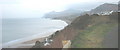
The cliff top path looking east at sundown
Image: © Eric Jones
Taken: 19 Dec 2007
0.10 miles
6
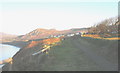
View eastwards along the clifftop above Porth Nefyn
Much of today's walk can be viewed from this point. The journey of some ten miles began in Trefor on the north side of the Eifl hills, which form the background in this photo. The walk took me to Porth y Nant and over Penrhyn Glas to Pistyll and on to Nefyn.
Image: © Eric Jones
Taken: 14 Dec 2007
0.10 miles
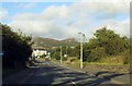
7
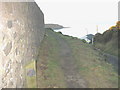
The start of the cliff-top path at the top of Lon y Traeth (Screw Road)
The cliff top path is a part of the Bardsey pilgrimage walk. The tip of Enrhyn Nefyn can be seen in the background.
Image: © Eric Jones
Taken: 19 Dec 2007
0.10 miles
8
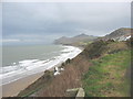
Cliff-top path
This section of the path is very popular with visitors and locals alike. In 2021 there were major rotational slips along these cliffs.
https://www.bbc.co.uk/cymrufyw/56813782
Image: © Eric Jones
Taken: 5 Jan 2008
0.11 miles
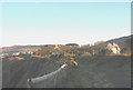
9
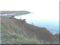
Site of a former cliff landslide
The bare scar has now been recolonised by vegetation.
Image: © Eric Jones
Taken: 19 Dec 2007
0.11 miles
10
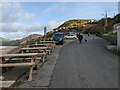
The car park at Nefyn beach
The picnic tables are for the café, out of shot on the right.
Image: © David Medcalf
Taken: 7 Nov 2021
0.11 miles