IMAGES TAKEN NEAR TO
Llangybi, PWLLHELI, LL53 6DX
Introduction
This page details the photographs taken nearby to LL53 6DX by members of the Geograph project.
The Geograph project started in 2005 with the aim of publishing, organising and preserving representative images for every square kilometre of Great Britain, Ireland and the Isle of Man.

There are currently over 7.5m images from over14,400 individuals and you can help contribute to the project by visiting https://www.geograph.org.uk
Image Map (Loading...)


Getting Data...Please wait
Leaflet Map data © OpenStreetMap
Images are licensed for reuse under creativecommons.org/licenses/by-sa/2.0
Notes
- Clicking on the map will re-center to the selected point.
- The higher the marker number, the further away the image location is from the centre of the postcode.
Image Listing (8 Images Found)
Images are licensed for reuse under creativecommons.org/licenses/by-sa/2.0
Image
Details
Distance
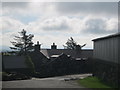
2
Brychyni Farm from Efail Pensarn
Brychni Farm is one of the largest farms in the district.
Image: © Eric Jones
Taken: 10 Apr 2010
0.03 miles
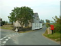
4
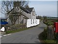
Efail Pensarn
Efail Pensarn means "road head smithy", the Welsh word for a smithy being "gefail". Most of old smithies ceased operating in the 1950s with the spread of mechanised agriculture.
Image: © Eric Jones
Taken: 10 Apr 2010
0.21 miles
5
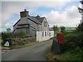
Efail Pensarn
One of the many former smithies dotted around the peninsula
Image: © Alan Fryer
Taken: 19 Sep 2015
0.22 miles
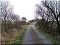
6
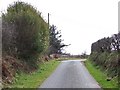
Approaching the T-junction at Efail Pensarn
The image is taken from near the end of the minor road from Clynnog Fawr which follows a track southwards along the eastern flank of the Gurn/Gyrn hills
Image: © Eric Jones
Taken: 10 Apr 2010
0.24 miles
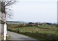
7
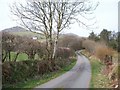
View along the road towards the woodland plantation in the valley north of Efail Pensarn
Tyddyn Mawr farm can be seen on the left.
Image: © Eric Jones
Taken: 10 Apr 2010
0.24 miles