IMAGES TAKEN NEAR TO
Lon Glenelen, PWLLHELI, LL53 6BX
Introduction
This page details the photographs taken nearby to Lon Glenelen, LL53 6BX by members of the Geograph project.
The Geograph project started in 2005 with the aim of publishing, organising and preserving representative images for every square kilometre of Great Britain, Ireland and the Isle of Man.

There are currently over 7.5m images from over14,400 individuals and you can help contribute to the project by visiting https://www.geograph.org.uk
Image Map (Loading...)


Getting Data...Please wait
Leaflet Map data © OpenStreetMap
Images are licensed for reuse under creativecommons.org/licenses/by-sa/2.0
Notes
- Clicking on the map will re-center to the selected point.
- The higher the marker number, the further away the image location is from the centre of the postcode.
Image Listing (58 Images Found)
Images are licensed for reuse under creativecommons.org/licenses/by-sa/2.0
Image
Details
Distance
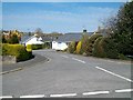
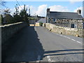
2
Modern housing at Ger y Bont
Ger y Bont means "by the bridge".
Image: © Eric Jones
Taken: 23 Apr 2010
0.05 miles
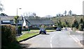
10
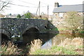
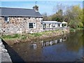
Pont Abererch Bridge
The bridge in the centre of the village carried the main road to Pwllheli over the Erch. The village was by-passed many years ago, and now the by-pass has been by-passed by the new A497, which runs to the South of the road shown on the OS map.
Image: © Alan Fryer
Taken: 27 Mar 2007
0.10 miles