IMAGES TAKEN NEAR TO
Efailnewydd, PWLLHELI, LL53 5TP
Introduction
This page details the photographs taken nearby to LL53 5TP by members of the Geograph project.
The Geograph project started in 2005 with the aim of publishing, organising and preserving representative images for every square kilometre of Great Britain, Ireland and the Isle of Man.

There are currently over 7.5m images from over14,400 individuals and you can help contribute to the project by visiting https://www.geograph.org.uk
Image Map (Loading...)


Getting Data...Please wait
Leaflet Map data © OpenStreetMap
Images are licensed for reuse under creativecommons.org/licenses/by-sa/2.0
Notes
- Clicking on the map will re-center to the selected point.
- The higher the marker number, the further away the image location is from the centre of the postcode.
Image Listing (13 Images Found)
Images are licensed for reuse under creativecommons.org/licenses/by-sa/2.0
Image
Details
Distance
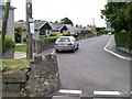
2
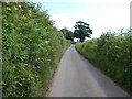
The narrow lane eastwards and upwards out of Efailnewydd
Image: © Eric Jones
Taken: 17 Jun 2010
0.06 miles
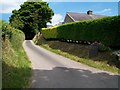
3
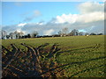
Farmland near Efailnewydd
The ground is soft after months of winter rain!
Image: © David Medcalf
Taken: 14 Jan 2006
0.11 miles
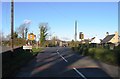
4
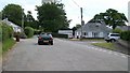
Approaching the eastern boundary of the village of Efailnewydd
Image: © Eric Jones
Taken: 17 Jun 2010
0.13 miles
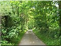
5
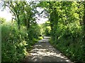
Country lane between Efailnewydd and Gorphwysfa
Image: © Eric Jones
Taken: 17 Jun 2010
0.14 miles
6
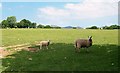
Sheep north of the Efailnewydd-Gorphwysfa road
Image: © Eric Jones
Taken: 17 Jun 2010
0.16 miles
7
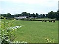
Fferm Goetre Farm, Efailnewydd
Goetre means "a settlement in the woods".
Image: © Eric Jones
Taken: 17 Jun 2010
0.18 miles